Notes on Williamsport
References
in C&O Canal Companion:
Mile 99.5
|
This
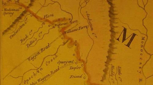
detail of Joshua Frye and Peter Jefferson's famous map
|
|
|
Added to Updated edition: The "Bollman bridge." Bollman was a self-taught engineer who began his career at age 15 laying track for the B&O Railroad. He later became the railroad?s foreman of bridges and designed the "Bollman truss," which had distinctive radiating struts. The design was used for as many as 100 bridges, including the post-Civil War bridge at Harpers Ferry, but heavier loads rendered it obsolete by the 1870?s. This relatively small bridge was built in 1879 and does not have the Bollman truss. An earlier bridge stood on these piers, carrying traffic to and from the "Good Ford" on the Potomac. During the battle of Antietam, Union General McLellan ordered Captain Charles Russell of the 1st Maryland Cavalry to destroy this bridge and the aqueduct to prevent a Confederate withdrawal. Russell?s caused minor damage to the aqueduct but did burn the bridge. This unpleasant duty capped an exciting week for Russell, a native son of Washington County, whose reconnaissance activities included slipping into Harpers Ferry during the siege and then back out again. The Second Corps of the Army of Northern Virginia (commanded by General Richard Ewell) used the ford and the rebuilt bridge on June 15 and 16, 1863, as they marched to Gettysburg. After that climactic battle, the Ewell?s Corps recrossed further upstream (using the aqueduct) because the Potomac was too high below the mouth of the Conococheague. The lift bridge just beyond the Bollman Bridge was built in 1923 to raise this piece of railroad track leading to the power plant; local lore says it was only used once before the closing of the canal in 1924 made it unnecessary.
To be addedMile 99.5 : Conococheague Creek had long been used as a path by Native Americans travelling down the Great Valley from what is now Pennsylvania, and later by settlers following the same route to the Shenandoah Valley. The Indian name proved a bit of a challenge for colonial officials, who referred to it variously as Conegocheek, Conegogeek, Conegocheige, Conegochiegh, and Conegogee. Evans Watkins established a ferry from Maidstone on Virginia shore in the 1740s and the Ohio Company built a stone warehouse at Maidstone as a part of its trade route across the Appalachians. In 1754, when Braddock arrived on the scene, Governor Sharpe was quick to recommend the advantages of transportation via the Maryland route: "I apprehend it will be the best & easiest way to land every thing that shall be sent up Potowmack for the Troops at Rock Creek whence our waggons will carry them to Conegocheek where Battoes [boats] may be made to convey every thing thence by water." Braddock hedged his bets by sending the 44th regiment of the Coldstream Guards up through Maryland, but when the roads west proved too primitive, they crossed at Conococheague (April 30, 1755) to catch up with the 48th Regiment, which was following the alternate route through the mountains of western Virginia. After Braddock's army was routed along the Monogohela River in July, many "back inhabitants" were reported to be fleeing from the western settlements and Conococheague. Governor Sharpe of Maryland arrived at Conococheague and stayed the panic by promising that Fort Cumberland would continue to be garrisoned, and ordering the construction of several small forts, including Fort Tonoloway (see mile 124). Even so, by September the Governor was reporting that "the Country is deserted for 30 Miles Eastward of Colo Cresap's who is also removing or removed down to Conegogeek where one of his Sons inhabits." [Cresap was based at Oldtown, see mile 167.] The following May, Virginians killed a French ensign who was travelling with a party of hostile Indians, and found orders from the commander at Fort DuQuesne in a little bag tied about his Neck, instructing him to destroy the magazine of provisions left at Conococheague by the Braddock expedition. That September, war parties approaching Conococheague from the north set off another panic, causing Governor Sharpe to lament that "this Accident has so terrified our Back Inhabitants that Hundreds of them have abandoned their plantations & one of our most flourishing German Settlements is on the Brink of being entirely broke up." After the Revolutionary War, General Otho Williams set out to establish a town at the mouth of the Conococheague. The Maryland Assembly passed an act of incorporation in 1787, and General Williams' brother, Elie, supervised much of the early development of the town. In 1790, when Congress voted to establish the Federal City somewhere on the Potomac, it specified the mouth of the Conococheague to be the upstream limit for placement of the capital. In October of 1790, President Washington himself came up the river to look at possible sites on the Monocacy, at Shepherdstown, and at Williamsport. After a warm reception in Elizabeth Town (Hagerstown), Washington met with Elie Williams at Williamsport on the 21st. But even Washington, who had chartered the Patowmack Company to build canals around the falls on the Potomac, must have realized that he could not count on navigation this far upriver. Many historians suspect that he had already decided to place the city next to Georgetown, and only toured the other sites as a negotiating ploy. Nevertheless, the landowners in the area took the trip quite seriously and forwarded various proposals to the president, including a plat of Williamsport. Williamsport endured several hostile visitations during and after the battle of Antietam (September 17, 1862). Six days before the battle, Jackson's men crossed into West Virginia from Williamsport as a part of the action to encircle Harpers Ferry. At some point just before the battle of Antietam, General George McClellan ordered Captain Charles Russell of the First Maryland Cavalry to destroy the bridge over the canal at Williamsport to prevent its use in the event of a Confederate retreat. By noon on the day of the battle, Union "vedettes" had reported that the bridge had been burned and (incorrectly) that the Conococheague Aqueduct had been destroyed. This concluded a remarkable ten-day span for Captain Russell, whose men had skirmished with Confederates at Point of Rocks on September 7th (killing 3 and capturing 17), scouted the Confederate column at Frederick on the 9th (capturing 13 men and 9 horses), reported on a skirmish at Williamsport on the 11th, rejoined the Federal troops besieged at Harpers Ferry on the 13th, slipped through enemy lines on the night of the13th, and delivered a message to McClellan at Frederick, Maryland, on the next morning. A few months later, promoted to Major, he was a key witness in the hearings to determine the reasons for Colonel Miles's controversial surrender of Harpers Ferry. After the Confederate army had crossed from Sharpsburg back into West Virginia, Robert E. Lee directed J.E.B. Stuart to take a force back across the fords at Williamsport and make a "demonstration" against the enemy. Stuart held the town for two days (September 19-20) before being forced to retire. His report notes that the canal bridge had indeed been burned, but his men were able to open a road under the aqueduct. Heros von Borcke, a Prussian cavalryman riding with Stuart's men, described their escape back into West Virginia:
Despite the generous exchange of ordinance, Stuart reported no men killed during the raid. Williamsport's most memorable war year was 1863, as Confederate troops passed through the town before and after the battle of Gettysburg. In mid-June of 1863, the Army of Northern Virginia crossed the Potomac at Shepherdstown, Falling Waters, and Williamsport. At Williamsport, they used a ford leading directly into the town, labelled on maps of the time as "Good Ford." The canal bridge was back in service, but the Confederates also cut four roads through the canal embankment to speed their passage. After the devastating battle of Gettysburg (July 1-3), Lee's entire army retreated to Williamsport, where they found the Potomac swollen by flood waters. By July 13, they had managed to reconstruct their pontoon bridge down at Falling Waters, and they began yet another harrowing night time crossing there and at Williamsport. In Williamsport, the water was too deep to use the Good Ford, so the soldiers swarmed into the canal bed and through the Conococheague Aqueduct to get to a fording place just above the mouth of the Conococheague. After the Civil War, the canal bridge was replaced by a bridge designed by Wendell Bollman. Bollman was a self-taught engineer who had begun his career laying the first track for the B&O Railroad. The "Bollman truss" was used extensively by the railroad, most notably for the reconstruction of the Harpers Ferry bridge after the war. However, by the 1870s this truss had proven inadequate to handle the increasing loads. The canal bridge, built in 1879, is a relatively rare "pony-Pratt" truss -- the classic Bollman truss had a very distinctive pattern of radiating struts.
|
|
A
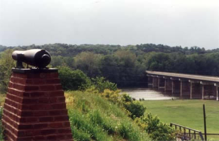
cannon on Cemetery Hill overlooks the "Good Ford" on the
Potomac, |
|
Additional NotesAbner Doubleday: One of the celebrated events in Williamsport history was the arrival of Abner Doubleday, the man at one time credited with coming up with the first rules for baseball as a twenty-year old West Point cadet in 1839. However, Doubleday's battery was stationed at Williamsport very early in the war, not in 1863 as the marker on Cemetery Hill proclaims. The Official Records pinpoint Major Doubleday as just having arrived at Williamsport in June 19, 1861, about two months after he had fired the first Union shot in the war at Fort Sumter. His stay was likely brief, as General Patterson was already planning to station Doubleday on the Maryland side of the river at Harpers Ferry to guard the workers rebuilding the bridge there. This appears to have happened within a matter of days, and subsequent orders suggest that Doubleday moved with Patterson?s men around the region through July. With one exception, the Official Records are silent on Doubleday's movements through the remainder of the year (he was directed to place pickets along the river from Mercersville to Dam #4 in October). By 1863 Doubleday had risen to the rank of Major General and had fought at Second Manassas (Bull Run), South Mountain, Antietam, Fredericksburg, Chancellorsville, and Gettysburg. After Gettysburg he was assigned to a military commission in Washington. According to Joseph Chance, who has recently edited and published Abner Doubleday?s "reminiscences," Doubleday was identified after his death as the inventor of baseball at least in part because the Mills Commission (1905-1907) was seeking to establish an American origin for the game to counter the claim that baseball was a descendant of the English game of rounders. The chairman, Albert Mills, was a friend of Doubleday?s, having met him in 1873. The commission was the brainchild of Albert Spaulding (founder of the sporting goods company), and the committee?s documentation was kept at Spaulding?s American Sports Publishing Company. However, inconveniently or conveniently, a fire at the Company destroyed these records. All that remains is a letter from a Cooperstown resident who stated that as a young cadet in the early 1840s, Doubleday taught the local boys to play a variation of "town ball," with fewer players, fixed locations in the field, and flat stones for "bases" rather than wooden posts. Bollman and his bridges: The best-known example of the Bollman truss in this region was the post-war bridge at Harpers Ferry which was destroyed by flood. The only surviving example of the Bollman truss can be viewed at Savage Mills, in Savage, Maryland. The Historic American Engineering Record (HAER) describes this as a "single-span wrought-iron pony-Pratt truss," 67 feet long, 13 feet 3 inches wide, buillt by the Patapsco Bridge & Iron Works, Wendell Bollman, proprietor. The HAER says that this is one of only two known pony-Pratt truss bridges by Bollman in Maryland (and likely, the U.S.). "Bollman ... is notable for his design and patent of the first all-iron bridge used consistently by a railroad."
|
|
|
Sources:
Also on the Web:
|