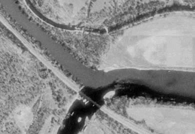
This
USGS aerial photograph shows the relative sizes
of the North and South Branches of the Potomac
at their juncture just below Oldtown, Maryland.
(United States Geological Survey)
|
Documents
from
Governor Sharpe's letter to Lord Calvert, September 14. 1753 (page 5,
Volume 6, Archives of Maryland).
Mr Cressop gave it as his Opinion to the Council that the Temporary
Line is to the Northwd of any Bendings of the River Potomack & that
the South Branch runs 60 or 80 Miles farther West then the Spring
Head of the Northern Branch upon wch representation of His by Advice
of the Council I have wrote the following Lettr to Ld Fairfax.
****
[Sharpe to Lord Fairfax.] My Lord I have the honour of acquainting
your Lordship with my appointment to this Government and at the same
time expressing Sincere Satisfaction from the hopes of being instrumental
in forwarding a mutual Benefit to your Lordship as well as the Lord
Proprietary of this Province Lord Baltimore was pleased to Charge
me with an Enquiry into the True Meridian and Place of the Fountain
head of Patowmeck; The best Information I have been hitherto able
to procure gives me Reason to believe there has been a mistake in
fixing the Spring head to the North Branch since the Length with other
Circumstances more properly denotes the Southern Branch commonly called
Wappacomo to be the main & principal Course of that River. I am the
more willing to be persuaded of the Truth of this Representation from
the considerable Advantage that will accrue to your Lordship. That
Branch I am Informed has never been thoroughly explored and traced
to it's Source, but I flatter myself with having your Lordship's Concurrance
for such an Examination into its Course Length Width and Depth as
may bring this Matter to a nearer degree of Certainty and if that
should appear to be the fountain head of Patowmeck River I shall not
Question but your Lordship will be for taking such measures as may
ascertain the mutual Limits of the two Proprietorships Agreeable to
the Direction and True Intention of their Respective Charters.
|
from
Governor Sharpe's letter to Lord Calvert, November 29. 1753 (page
14, Volume 6, Archives of Maryland).
My intent to examine the two Branches of Potowmack I have hinted
to the Govr of Virginia & writ to Colo Cressop to know whether He
will undertake that Business or not, & re- turn me an accurate Description
of their Courses, Rapidity & Depth & the longitudinal Difference
of the places of the Spring Heads, but I suppose the severity of
the Winter will hinder Him from proceeding on those Enquiries this
three or four Months at least.
|
|
from
Lord Calvert to Governor Sharpe, April 17th, 1754 (pages 44ff, Volume
6, Archives of Maryland)
By Lord Fairfax's Letter to you, his Lordship Declines having to
Do with any Re-Settlement of the Course of Potomack River. The Branch
called the South Branch which you seem to apprehend will be much more
Beneficial to Maryland, as in Length South Westward, will depend on
Proof, as it's Fountain Head instead of the Spring Head of the said
River, determined by the Virginia Commissioners in 1736 and 1737.
If the South Branch runs as you apprehend, it will certainly be of
great Advantage to the Encrease of Maryland, and also may be to Lord
Fairfax's Tract of Land by the Spring head of Potomack lying more
Westward than the Determin'd Head of Potomack as above settled. However
you ought before you make an Attempt, to be well Grounded How the
Inclinations of the Governor, the Virginians and Lord Fairfax Stand,
to a New Settlement of the Course and Fountain of Potomack with Maryland.
If they oppose, the Crown is most likely will side with Them. The
Tryal of the South Branch of Potomack as to it's advantages as may
turn out, His Lordship is not against Mr Cressap's Essay therein ;
Provided he does not bring upon Him too great Cost thereby, of which,
if you find it absolutely necessary to send him; you must Bargain
with him Reasonably.
|
from
Governor Sharpe's letter to Lord Calvert, June 6, 1754 (pages 70-72,
Volume 6, Archives of Maryland).
... It is owing to Colo Cressap's Absence from home
among the Virginians on Ohio, that I am not yet able to comply with
your Requisition concerning the Latitude of the most northern Bend
of Potomack I some weeks since writ two Letters desiring him to return
me a Copy of his Map of that River signed & authenticated which I
will transmit with the Description of Distances & Bearings of the
River Heads on the Eastern Shore as soon as the Surveyors make their
Returns which I expect in about 3 weeks or a month at farthest ...
****
P. S. I have this Instant received a Letter from Colo Cresap with
the Plan & Certificate concerning the North Branch of Potowmack &
the Temporary Line as run by him.
|
|
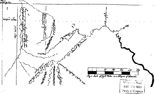
Facsimile
of Cresap's Map:
|
|
From
Charles Fenton Mercer's December 1832
reports to the Directors of the Canal Company:
Let the next
dam, No. 7, be erected in like manner, immediately below the South
Branch of the Potomac, and a Canal, twenty-five miles in length, be
conducted from thence, to the highest point, on the pond of still
water, behind dam No. 6, whence a navigation for the Canal boats,
or six feet depth of water, can be had down to the dam. The dam, at
the mouth of the South Branch, will cause a still water navigation
to extend as far up the Potomac as above Alum Hill, a distance of
three miles.
* Alum
Hill is at Oldtown. This
1832 proposal was based on the use of stillwater navigation behind Dams
4-8, but promised that this would be a temporary expedient. Dam #7,
which was initially intended to be built just below Potomac Forks, was
never constructed.
|
|
Sources:
- Sharpe/Calvert
correspondence is from Volume 6 of the Archives
of Maryland, Correspondence of Governor Horatio Sharpe,
Volume I, 1753-57, William Hand Browne, Maryland Historical Society,
Baltimore, 1895. [On-line at Maryland
State Archives]
- Facsimile
of Cresap's map of the South Branch from Library of Congress, Maps
and Geography Division. [The
facsimilie appears in Archives
of Maryland, Volume 6, Correspondence of Governor Horatio
Sharpe, on-line at Maryland
State Archives -- the location of the original map is not indicated.]
- "Two
Reports of the President to the Directors of the Chesapeake and Ohio
Canal Company on the Present State of the Finances of the Company,
and an Extension of the Navigation of the Potomac to a Point Nine
Miles Above the Town of Cumberland," signed by C.F. Mercer, December
15, 1832, printed by Gales and Seaton, Washington, DC, 1832.
Also
on the Web:
|
