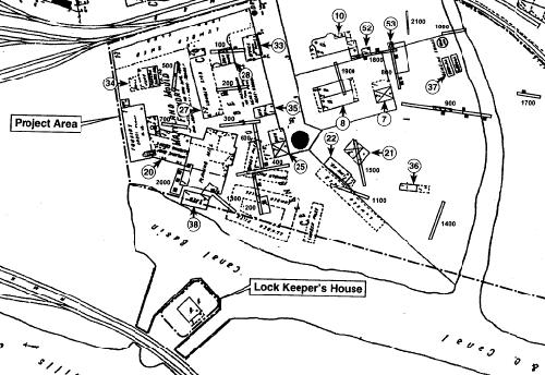
Detail
of a 1921 Sanborn map of the canal terminus three years before the
1924 flood put it out of business. The "Little Basin," which
extended to the left
had been sold to the Western Maryland Railroad at this time.
(From Canal Terminus study--labels added to key features)
|
|
7 - Shed,
Gerbig Soap Factory
8 - Gerbig Soap Factory, later reconfigured into a duplex for Footer
Dye Works employees.
10 - Mateus Gerbig residence, changed to housing for Footer Dye Works
employees in 1909.
20 - Holmes Foundry building, north side is planing mill.
21 - 2-story building west of soap factory, purpose unknown.
22 - Lime storage building west of soap factory.
25 - Building on Maryland Foundry property, purpose unknown.
|
27 - Lumber
shed on Maryland Foundry property.
33 - Office/building on Maryland Mould Factory property.
34 - Building on Maryland Foundry property, scales, junk, and pattern
warehouse.
35 - Office/building on Maryland Foundry property.
36 - Shed on south side of project area.
37 - Benzine storage tanks.
38 - Shed on Maryland Foundry property.
52 - Outbuilding behind residence, purpose unknown.
53 - Outbuilding behind residence, purpose unknown.
|
To be added
To
be added to Mile 184.5 note:
The
canal company originally planned to build this dam about a mile above
Cumberland, which also meant building an aqueduct across Will's Creek.
One of the advantages was that the still water behind the dam would
extend for as much as 8 miles further upriver, bringing it that much
closer to Georges Creek and the coal beds. Later, the company talked
about building the dam one mile below Cumberland, before it
finally determined to placed it just below the mouth of Will's Creek.
***
To
the west of Wills Creek, well-to-do residents built their houses along
Greene Street, which led to the road over Wills Mountain. On the east
side, the canal basin and the B&O tracks beyond formed a bustling
and sometimes ramshackle commercial district.
|
Web Notes
From
canal terminus study:
A recent
study (2000) of the canal terminus in Cumberland identified a variety
of businesses that operated in this vicinity. Many of the properties
changed shape as owners came and passed on, and portions were sold
or acquired. Some of the better-known businesses were:
Ward's
or Weld's Boatyard -- established by William L. Ward, an attorney,
merchant, and canal advocate, around 1850-51. Referred to as Weld?s
Boatyard in ensuing years, though it is not clear whether ownership
passed on to Henry Thomas Weld, or was a partnership. By 1876, Weld
and David Sheridan were listed as partners in "Weld & Sheridan,
Boat Building and Repair Yard," continuing until the 1890s, when
most of the property was purchased by Henry J. Glick and George D. Landwehr,
who owned Landwehr & Glick Lumber Yards.
Footer's
Dye Works -- Started by Thomas Footer, an immigrant from Yorkshire,
in a one-room basement in 1870, this concern expanded to a half-block
by the 1890s. In 1904, Footer purchased property from Landwehr, filled
in a portion of Shriver?s Basin, and proceeded to erect a number of
four story buildings for the cleaning and dyeing of fabrics.
Queen
City Foundry/Holmes Foundry (1904)/Maryland Foundry (1910)--later
purchased by Glick and Landwehr and renamed the Maryland Mould Foundry
(1921), which made sash weights for windows.
Cumberland
Soap Factory--started by Mateus Gerbig, who sold this property to
Footer's in 1909. Footers converted the factory building to a duplex
residence for employees with families.
Cessna
Lumber Company--built on portions of the Weld and Sheriden Boat
Yard and other properties, purchased by Bauer Lumber Company in 1956
and operated under that name until 1997.
|
Documents
From
Charles Fenton Mercer's December 1832
reports to the Directors of the Canal Company:
Let another
dam, No. 8 ... be erected at the Ledge of Rocks described by the United
States Engineers, in their report to the Department of War, of October,
1826, as situated one mile above Cumberland; and let a Canal be constructed
thence, at an elevation of thirty-one feet, in passing through Cumberland,
a distance of 15-1/2 miles as proposed by the United States' Engineers,
to the head of the pond above dam No. 7. Dam No. 8 will produce, as
those Engineers have stated, still water navigation for the distance
of eight miles of river above its position ... It will approach within
nineteen miles of the mouth of George's Creek, or Western Port, at
the base of the Alleghany, where are to be found, in Savage Mountain,
the richest coal banks of the valley of the Potomac.
* This
1832 proposal was based on the use of stillwater navigation behind Dams
4-8, but promised that this would be a temporary expedient. As it turned
out, stillwater navigation became permanent behind Dams 4 and 5, but
was not employed behind Dams 6 and 8. Dam #7, which was initially intended
to be built just below Potomac Forks, was never constructed.
From
the ninth annual report to the stockholders
dated June 12, 1837:
A change has
recently been determined upon for the site of the feeder dam at Cumberland.
It was at first contemplated to place this dam one mile below the
town; the site recently adopted is immediately at Cumberland, a few
hundred feet below the mouth of Will's creek. By this arrangement,
we are enabled to make a guard bank that will protect the basin in
Cumberland, and the town itself, against injury from high water of
the river, to which they would have been more or less subject with
the former location of the dam. The basin willnow be under the same
control as the water of the canal, and will be kept at a uniform height.
Warehouses and buildings may consequently be put upon it, without
any precaution being taken to place them above the reach of high water.
Besides, the basin can easily be drawn down, at any time, for the
purposes of improvements. In a few words, the present plan conducts
the independent canal directly into town, whereas, the former plan
terminated it a mile below.
|
|
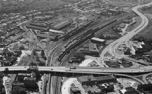
An
aerial view of Cumberland, showing the Queen City Hotel at lower right,
and the B&O shops to the upper left. Probably taken around 1971,
prior to
the demolition of the hotel. (More photos and documentation of these
structures
can be viewed on-line as a part of the Historical
American Engineering Record,
American Memory, Library of Congress)
|
|
Sources:
- "Two
Reports of the President to the Directors of the Chesapeake and Ohio
Canal Company on the Present State of the Finances of the Company,
and an Extension of the Navigation of the Potomac to a Point Nine
Miles Above the Town of Cumberland," signed by C.F. Mercer, December
15, 1832, printed by Gales and Seaton, Washington, DC, 1832.
- "The
memorial of the Chesapeake and Ohio Canal Company to the General Assembly
of Maryland," reprinted in Memorial of the Corporation of
the City of Washington, Remonstrating Against the Surrender to the
State of Maryland of the stock held by that Corporation in the Chesapeake
and Ohio Canal, March 11, 1840, printed by Blair and Reeves. [The
location of the dam above Cumberland is discussed on page 47.]
- "Ninth
Annual Report of the president and directors of the Chesapeake and
Ohio Canal Company to the stockholders, made June 12, 1837,"
reprinted in Memorial of the Corporation of the City of Washington,
Remonstrating Against the Surrender to the State of Maryland of the
stock held by that Corporation in the Chesapeake and Ohio Canal,
March 11, 1840, printed by Blair and Reeves.
- "Braddock
Road," by John Kennedy Lacock, in The Pennsylvania Magazine
of History and Biography, Vol. XXXVII, 1914. [This is a very detailed
tracing of Braddock's route across the Appalachians, starting at Fort
Cumberland and proceeding west--much attention is paid to the choice
of route through the Narrows.]
-
Cumberland
The End of the Line: Phase I and II Archeological Investigations
at the Terminus of the C&O Canal, Archeological Report Number
213, Prepared by Joseph Balicki, et al,, John Milner Associates,
Inc, for the State Highway Administration, Maryland Department of
Transportation, Baltimore, Maryland, 2000.
|
