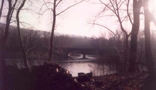
The
stone railroad bridge across the Great Cacapon in the winter of 1993.
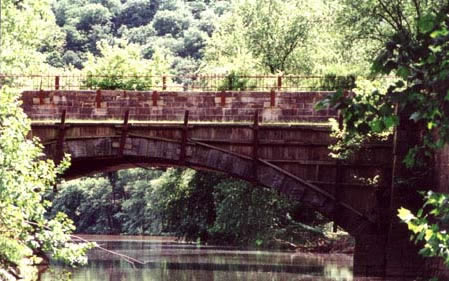
Below: Sideling Hill Aqueduct, in late spring 2001,
with Sideling Hill in the background. (Photos by M High).
|
|
Added
to Mile 134 in the Updated edition:
The
original plans for the Woodmont Rod & Gun Club have changed. The
club is now managed by Maryland?s Department of Natural Resources
in conjunction with the Izaak Walton League.
"Hunting
and hiking are permitted on the 2,000-acre property. For hunting information,
contact the Wildlife Heritage Division (301/478-2525). Groups may
arrange for use of the stone lodge; contact the Fort Frederick State
Park for more information."
Added
to Mile 136.2 in the Updated edition:
"The
original name, "Side Long Hill," is said to have appeared first on
the famous map of the mid-Atlantic region made by Joshua Fry and Peter
Jefferson in 1755. However, the name "Sidelong Hill Creek" appears
as early as 1736 on the map that Winslow produced for the Fairfax
survey. The Creek was chosen as the dividing line when the Maryland
Assembly created Allegany County out of Washington County on December
25, 1789. (Allegany thus became the westernmost county?Garrett County
was not created until after the Civil War.)"
|
To be added
Mile
133.7:
Intitially,
the canal company had intended to place its Dam #6 just below the
mouth of the Cacapon. However, by 1837 their engineers had concluded
that the riverbed below the Cacapon was unsuitable as a foundation
for the dam. In addition, the dam would have had to be higher to cross
the river here, and thus more vulnerable to floods. Not to be deterred,
the company came up with another scheme to capture the trade from
the Cacapon branch -- they proposed building a dam across the mouth
of the Cacapon and using it to water a short connecting canal up to
Dam #6, where the boats from the Cacapon would cross the slackwater
"pond" and enter the main canal. The possibility of a cross-river
connection soon became moot, when the B&O Railroad extended its
line along this stretch of the Potomac Valley and naturally placed
one of its stations on the Cacapon.
Mile
134.2:
As the
canal company put the finishing touches on Dam #6 in 1838, it began
to visualize, at last, a profitable connection with coal that would
be boated down from Cumberland in the fall, "when the waters
of the upper Potomac admit of navigation." However, the opening
of the B&O Railroad to Cumberland in 1842 brought a more practical,
if perhaps less agreeable solution. ***
|
Documents
|
From
Charles Fenton Mercer's December 1832
reports to the Directors of the Canal Company:
Let the next
dam, No. 6, be placed at the best situation for the next feeder which
is believed to be immediately below the mouth of the Great Cacapon,
and 26-1/2 miles above dam No. 5 ....
From
the ninth annual report to the stockholders
dated June 12, 1837:
A guard-lock
at the dam serves the purposes of a feeder to the canal, and for the
admission of boats navigating the pool, as well as for the reception
of the trade from the Cacapon, which by a dam across the stream at
its mouth, and a canal of less than one mile in length, may be connnected
with the main stem by means of the pool and guard lock. By former
surveys it was proposed to locate the dam a short distance below the
mouth of the Cacapon; but on a more thorough examination by our engineer,
he reportedly decided against the location at that point, mainly on
the ground that the bed of the river did not present a suitable foundation
for such a structure, and that the hazard of its being swept away
would be greatly augmented by its increased height at that point.
Other and substantial reasons were adduced, which decided the Board
in the adoption of the present location.
|
|
|
|
Official
Records,
Series 1, Volume 5
Page
1018
- message from General T. J. "Stonewall" Jackson:
HEADQUARTERS VALLEY DISTRICT,
Unger?s Store, Morgan County, Virginia,
January 2, 1862.
General JOSEPH E. JOHNSTON
Commanding Department of Northern Virginia:
MY DEAR GENERAL: Yours of the 31st ultimo is at hand, and tends
to confirm information previously received by we that an advance
was to be made on Winchester by forces from Reynolds and Banks.
I am taking a position such as to prevent their junction without
giving me an opportunity of striking a blow at one of them previously,
should circumstances justify it. Tomorrow I hope to recover Bath,
and before leaving Morgan I desire to drive the enemy out of this
county and destroy the railroad bridge which has been recently constructed
across the Big Cacapon. Reynolds? forces in and about Romney are
estimated at about18,000, but I think this is too large; yet I fear
that it is true. At last advices General Banks? headquarters were
at Fredericktown, but he has had ample time to change them siuce.
Very truly, your friend,
T. J. JACKSON
[Major-General, Commanding Valley Dist?rict.]
|
|
|
|
Pages
391-392 - from report of Gen. Thomas J. Jackson,
C. S. Army, of operations from November 4, 1861, to February 21, 1862.
The next morning (January 4) the march was resumed,
General Loring still in front, and continued without farther interruption
until within a mile or two of the town [Bath], when General Loring,
without sufficient cause, permitted the head of the column repeatedly
to halt, and thus lost so much time as to make me apprehensive that
unless I threw forward other troops I would have to remain out of
Bath another night.
***
So prematurely and repeatedly had General Loring permitted the head
of the column to halt, that even his skirmishers were not kent within
continuous sight of the enemy. Though I followed after the cavalry
and entered the town in advance of the skirmishers, yet both the enemy?s
artillery and infantry were out of sight. I moved on b- wards Sir
John?s Run Depot, the direction in which there was reason to believe
that they had retreated, until I had advanced sufficiently far to
prevent Colonel Gilham from missing the way to the depot. Immediately
afterwards I returned to the road leading to the railroad bridge over
the Big Cacapon River, and directed Colonel Rust to move to the bridge
and destroy it. I then returned towards Bath, for the purpose of following
in person the road taken by the fugitive cavalry, and which was the
only remaining one by which the enemy could have escaped, and on the
way directed Colonel Maney to continue scouring the hill that he was
then moving upon, and afterwards to join me.
***
On the evening of the 4th Lieutenant-Colonel Ashby, who, in command
of a detachment composed of some cavalry and an infantry force under
Maj. E. F. Paxton, and a working party under Capt. H. T. Colston,
had been enlarging the break in Dam No. 5, joined me at Bath. From
the most reliable information received the force of the enemy at Bath
was 1,500 cavalry and infantry, with two pieces of artillery. The
next morning I demanded the surrender of Hancock, stating that if
the demand was not acceded to the place would be cannonaded. The commanding
officer refused to comply with my demand, and I cannonaded the place
for a short time, and proceeded to construct a bridge for crossing
the Potomac about 2 miles above the town. This work was intrusted
to Col. W. A. Forbes, who commanded and progressed with it in a manner
highly creditable to himself and his com- mand. Colonel Forbes was
assisted in this work by Captain Briscoe, assistant quartermaster,
an enterprising and valuable officer. On the 6th the enemy was re-enforced
to such an extent as to induce me to believe that my object could
not be accomplished without a sacrifice of life, which I felt unwilling
to make, as Romney, the great object of the expedition, might require
for its recovery, and especially for the capture of the troops in
and near there, all the force at my disposal. The invader having been
defeated and driven across the Potomac, the telegraph line broken
at several points, and the railroad bridge across Big Cacapon destroyed,
thus throwing material obstacles in the way not only of transmitting
intelligence from Romney to Hancock, but also of receiving re-enforcements
from the east, arrangements were made for moving on Romney. The next
day, the 7th, the command was put in motion; Lieutenant-Colonel Ashby,
with his cavalry, brought up the rear; but before leaving Alpine Depot,
opposite Hancock, destroyed a large amount of public stores that had
fallen into our hands and could not be removed for want of means.
***
|
|
|
Sources:
- Frontier
Forts along the Potomac and its Tributaries, William H. Ansel,
Jr., Springfield, West Virginia, 1984, reprinted by Fort Pearsall
Press, Inc., 1995. [Ansel bases the name "Fort Dawson" on
the possibility that the fort at the mouth of the Cacapon was built
on land owned by Isaac Dawson, and was perhaps constructed by Dawson
and his neighbors. However, I have not found the name used in the
correspondence of Washington, Sharpe, or Dinwiddie, or in the proceedings
of the General Assembly of Maryland.]
- Report
of Gen. Thomas J. Jackson, January 4, 1862- Skirmish at Great Cacapon
Bridge, from Official
Records,
Series 1, Volume 5, pages 391-395.
- "Two
Reports of the President to the Directors of the Chesapeake and Ohio
Canal Company on the Present State of the Finances of the Company,
and an Extension of the Navigation of the Potomac to a Point Nine
Miles Above the Town of Cumberland," signed by C.F. Mercer, December
15, 1832, printed by Gales and Seaton, Washington, DC, 1832.
- "Ninth
Annual Report of the president and directors of the Chesapeake and
Ohio Canal Company, to the stockholders, made June 12, 1837"
and "Tenth Annual Report of the president and directors of the
Chesapeake and Ohio Canal Company, to the stockholders, made June
4, 1838." reprinted in Memorial of the Corporation of the
City of Washington, Remonstrating Against the Surrender to the State
of Maryland of the stock held by that Corporation in the Chesapeake
and Ohio Canal, March 11, 1840, printed by Blair and Reeves.
Also
on the Web:
|
