Notes on the Catoctin Tunnel & Ridge
Reference in C&O Canal Companion: Mile 48.4
|
The
Piedmont valley comes to an abrupt end at Point of Rocks, where |
|
|
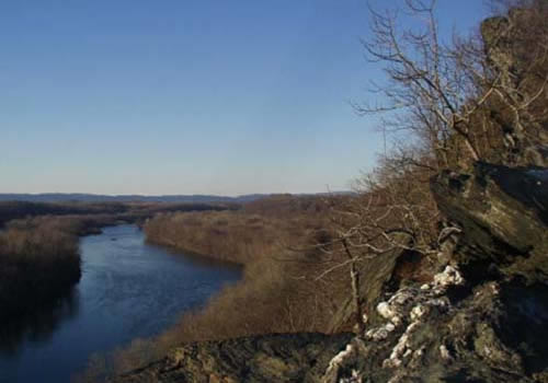
Looking
west from the slope of Catoctin Mountain, in Maryland,
|
|
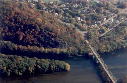
To be addedMile 48.4: This is where things narrowed to a point between the railroad and the canal. The B&O Railroad started buying up the land along this ten-mile stretch to Harpers Ferry, which had a number of extremely narrow passages through the first Appalachian ridges. The canal company sought an injunction in 1828, claiming that it had a prior right to the route based on its charter. After a four year court fight, the canal company had prevailed, but was financially exhausted. The Maryland General Assembly insisted that the canal company share its right-of-way with the railroad, at least as far as Harpers Ferry. It was an especially tight squeeze here, though after the Civil War, the B&O made things a little easier by driving tunnels through two spurs of the Catoctin (1868). Two tracks ran through these tunnels until the modern era -- with the C&O out of business, the railroad was able to run one track through the tunnel and the other around the ridge. In 1949, the railroad also began dumping earth, ballast, and cinders into the bed of the canal between here and Brunswick, with the acquiescence of the Park Service, which had given up any thought of rewatering the length of the canal and was considering a plan to fill it up and turn it into a parkway. Over the years, blocks of stone, railroad ties, and equipment have also tumbled into the canal; as one Park ranger used to observe, you could probably find enough parts here to build your own locomotive. *** When Virginians voted to secede from the Union on May 23rd, Colonel Jackson and his Major Turner Ashby no longer felt constrained by diplomatic niceties, and Ashby sent some men up the ridge to blast the Bollman Rock. Their first attempt was a failure, but by the 27th the C&O Canal Company's president, Alfred Spates, observed that they had succeeding in blasting enough rock off the cliffs to completely block the railroad and threaten canal navigation. (Spates had gone up to Harpers Ferry to negotiate with Jackson to allow the passage of canal boats.)
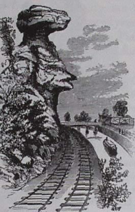
A
rather dramatic interpretation of "Bollman's Rock" overhanging
The ridge of the Catoctin was an important signal post during the Civil War, not just for observation of this stretch of the Potomac, but as an intermediary between the signal stations on Maryland Heights and Sugarloaf Mountain, which in turn could signal Union forces at Frederick. During the first Maryland invasion, as Union forces were retaking Point of Rocks on the night of September 12th, 1862, Lieutentant Fralick of the signal corps scrambled up this ridge to establish communications with the station on Sugarloaf Mountain. His attempts to signal the embattled Union contingent on Maryland Heights by firing rockets and "red lights" were unsuccessful, because the signal officer on the Heights had "so far misapprehended the position in which he could be of most service as to leave the Heights prior to their investment." With the rest of the Army of the Potomac, the Signal Corps packed up and left for points south at the end of October 1862, but they would return to the Great Valley in the aftermath of Gettysburg (see notes to Mile 109.6). Mile 50.9: This is likely where Mosby's men crossed the river on July 4, 1864, on their "Calico Raid" to Point of Rocks. They had come down the Virginia shore from opposite Berlin, towing a small cannon which they used to shell the Union pickets during the crossing. Splashing across the river to a small island and then on to the Maryland shore, Mosby's men drove the pickets up onto the ridge. An excursion boat, The Flying Cloud, was approaching from upstream, carrying a group of Treasury clerks who had been on an ill-timed holiday visit to Harpers Ferry. With no one willing to venture out and operate the lock gates, the boat was an easy prey, so the clerks jumped in the canal and made their escape. The raiders set it on fire and then made their way down the towpath towards Point of Rocks.
|
|
DocumentsReported in the Baltimore American, May 27, 1861: MINING THE BOLLMAN ROCK. Passengers who
have travelled on the Baltimore and
|
|
|
Sources:
|