Notes on Clear Spring & Fairview Mountain (aka North Mountain)
Reference in C&O Canal Companion: Mile 106.9
|
A
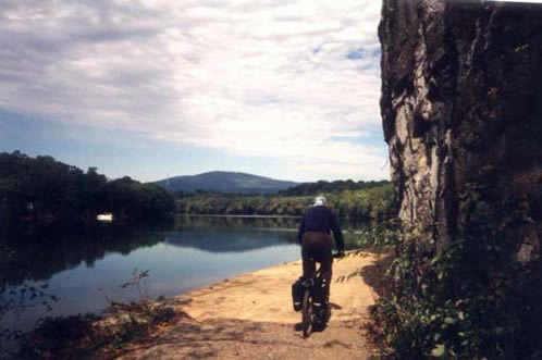
through-cyclist passes the cliffs above Dam #5,
|
|
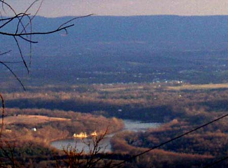
To be addedMile 106.9: Fairview Mountain was occasionally used by the Union Army as the westernmost observation post and signal station in the Great Valley (see Mile 109.6). Mile 108.2: After Dam #5 was put into service by the canal company in 1834, the annual report to the stockholders noted that the slackwater area extended up to Charles Mill, which was within two miles of the stage coach traffic on the National Road at Clear Spring, and asserted that eastbound passengers "after the fatiguing transit of the mountains, will find this mode of conveyance an agreeable relief, and will take the canal route," which featured "the magnificent scenery of the Potomac, and, at the same time, two of the greatest works that have been executed in our country." As was the case with so many of the company?s optimistic projections, the anticipated crossover passenger traffic from the National Road never materialized. If the Company directors who escorted a party of dignitaries up to Harpers Ferry in May 1834 were aware of John Quincy Adams' rather humdrum impressions of the slow-moving scenery, they managed to conceal their doubts in this report. In the end, travellers were not forced to choose between continuing a rattling coach-ride on the National Highway or switching to a slow boat to DC -- they could cover the whole route in a fraction of the time on smooth rails. By 1858, the writer Porte Crayon was riding the Baltimore & Ohio and marvelling in Harper's New Monthly Magazine: "the wonderful achievement was more fully realized by the rapid, unbroken sweep over the whole length of the rail from Wheeling to Baltimore, 379 miles in 16 hours, without an incident, a jolt or the slightest discomfort." Mile 109.6: The first ridge at the western end of the Great Valley was called North Mountain in colonial times. That name has been retained south of the Potomac, but above the Potomac, it has become known as Fairview Mountain. Fairview indeed has good view of the Great Valley to the east, as well as to the western mountains. This was probably the mountain that Mason and Dixon ascended in October 1765, to confirm that the line they were surveying for the Maryland-Pennsylvania border would not intersect the Potomac as they continued to plot its course west. During the Civil War, the Signal Corps for the Union Army used Fairview Mountain as an observation post during and after the battle of Antietam, and again at the end of the Gettysburg Campaign. In 1862, several weeks after the battle at Antietam, this signal station was captured by J.E.B. Stuart's cavalry at the beginning of his raid on Chambersburg, which is also remembered as Stuart's second ride around McClellan's Army of the Potomac. The Union signal officers were absolved of negligence because of a dense fog in the river valley on the morning of October 10th, which obscured the crossing of Stuart's cavalry at McCoy's Ferry (just ahead, see Mile 110.2). The Signal Corps returned in July of 1863, after the battle of Gettysburg. Though they succeeded in establishing a line of communication across the valley (to Elk Ridge, near Harper's Ferry) through a signal station at Downsville, they were not able to observe Lee's movement across the river until it was too late. Fairview Mountain is now part of the Indian Springs Wildlife Management Area.
|
|
Documents |
|
|
From Charles Mason's journal, October 27, 1765:
Mason mentions two visits to North Mountain in October 1765 to see "the course of the River Potowmack Westward." On the 26th, they found the air to be too hazy, but had better success on the 27th.
|
|
|
|
|
|
Report
of one of the signal officers at Fairview Mountain, Albert J. Myer ...SIR: In compliance with orders from
Headquarters Arlny of the Potomac, I have the honor to report that,
on October 10, 1862, our signal party was surprised by a body of rebel
cavalry, about 8 a.m., approaching the station. During the morning,
the valley along the river was filled with a dense fog, which prevented
seeing any portion of the river. The point at which the rebels crossed
the river is hid entirely from view from any point on this mountain;
also, the road over which the force came after leaving the river is
not visible, not even the slightest portion of it, from anyplace upon
this mountain. The turnpike leading over the mountain, and which they
crossed about 1 mile below our station, is winding, and can be seen
from no one point but at a very few rods from our station it can be
seen about 20 rods. Here it was we first saw the rebel cavalry approaching.
They were on us in a very short time from our first seeing them. We
had just succeeded in saddling our horses, at least part of us; Privates
Vincent and Emge had not finished saddling theirs, which accounts
for their capture. They were trying to save their horses with themselves.
The men lost all their extra clothing, 3 McClellan saddles and bridles,
2horses, 2 full sets flags, 1 saber, 3 pistols, 2 telescopes, 2 marine
glasses, and 2 kites, none of which have beeni recovered W. W. ROWLEY, |
|
|
Sources:
Also on the Web:
|
|