HÀ TIÊN
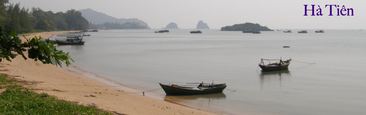
It is always a pleasure to come to Hà Tiên, at the far end of a long journey around the peninsula. Lodged in hilly terrain around a sheltered harbor, it is a lovely landscape with a remarkable history, having once been an independent city-state whose rulers vied with the rulers of Ayutthaya for dominance in the Gulf of Thailand. Hà Tiên has several historic hill-sites that are suitable for hiking, most of them within easy cycling distance from the town. Yet it has never really been promoted as a destination for foreign tourists, who are presumed to be more interested in the white-sand beaches of Phú Quốc island.
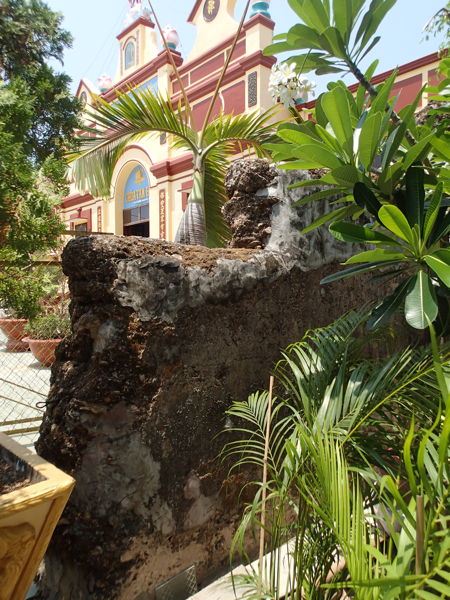
This is believed to be a remnant of the wall of the old Mạc citadel, still standing next to the Tam Bảo pagoda that was originally endowed by Mạc Cửu.
Oddly, my introduction to the exotic history of the Mạc kingdom came not from any French or Vietnamese sources, but through the work of Nicholas Sellers, an officer who was stationed at the Special Forces camp overlooking the town during the “American war.” In 1983, Sellers published The Princes of Hà Tiên in Brussels, of all places. The publisher was listed as Thanh Long, evidently referring to the ancient name for Hanoi, but this may have been a fictive establishment that Sellers invented for this one book. Though the physical appearance of the book is unprepossessing—the text appears almost as typescript—the work itself is a fairly sophisticated synthesis of materials ranging from the accounts of French and Chinese visitors in the 18th century to the Mạc family history. [The latter presumably written in Han Chinese and/or translated into quốc ngữ—Sellers gives credit to a learned man of the town, Quách Ngọc Bá, for his assistance in this regard.]
Sellers begins the historical narrative on a personal note, associating the early days of the Mạc settlement at Hà Tiên with the founding of his native state of Pennsylvania in 1681:
On almost precisely the same date that William Penn secured a grant and the royal assent to his Pennsylvania colony in the New World, on the opposite side of the globe a Chinese adventurer by the name of Mạc Cửu had succeeded in establishing a small state under very similar auspices
... There are curious likenesses between the early histories of Ha-tien and the Pennsylvania colony. Each owed its existence in 1681 to a sole founder: in both cases a man of singular vision, leadership and compassion. Both states were brought into being by the favor of a remote monarch and both were peopled by refugees seeking to live in peace. harmony and simple prosperity
... Most significantly, both Pennsylvania and Ha-tien in their own times captivated the particular interest of the European intellectual community, who contrasted the political experimentation of those new states, and the tranquil prosperity enjoyed by each, with the troubled and tyrannical nations of Europe.
The similarity of dates is not nearly as exact as Sellers implies, as we have no documentary evidence to confirm when the Cambodian king placed Mạc Cửu in charge of this once-active port town. But the rest of the comparison holds true, even if it is—as Sellers freely admits—no more than coincidence.
Of the terrain, he writes:
Around Ha-tien and to the immediate north in the « Seven Mountains» region, are to be found the only mountains and hills in the Delta. These are precipitous slopes which were once islands in the Bay of Thailand, and now, rising incongruously from the flat rice fields or coastal swamps, still have the aspect of islands in a grassy sea. Oyster shells embedded in the rocks can be found high up in these hills, indicating that the sea level must have been two hundred feet above its present level, and suggest that a gradual geographic upheaval may have accompanied the accumulation of alluvial deposits. The large island of Phu-qu6c, (4) and the scattered smaller ones such as Pula Dama, Pula Panjang and Pulo Way, are the remains of this island chain.
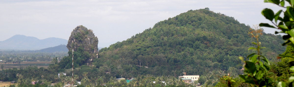
The karst outcropping with the Cloud-Swallowing Stone Grotto (Thạch Động), as seen from Screen Mountain (Bình San). Both landmarks were celebrated by Mạc Thiên Tứ in his Ten Odes. Photo by Mike High.
Sellers goes on to give a full account of the rising prosperity of Hà Tiên and the laudatory descriptions penned by Chinese envoys and the French adventurer and philosophe, Pierre Poivre, continuing the tale through the wars with Siam and the Tây Sơn, and then into the 19th century. Sometimes it colorizes the story of the first two Mạc princes with sentimental assumptions, but the work is sound enough to find its way into an occasional scholarly citation.
Princes of Hà Tiên was a remarkable accomplishment, but as far as I know, it is the only book that Sellers ever published, aside from a genealogical history of his own family in Pennsylvania. So, his book on Hà Tiên is a one-of-a-kind thing, found only in the holdings of a few dozen libraries around the world.
Since the Princes of Hà Tiên, a great deal more has been written in English about Hà Tiên, as listed in the “Readings” section below.
The Mạc Family in Hà Tiên
Hà Tiên’s heyday as a prosperous city-state was brief but very bright, spanning the lifetimes of two great lords. According to several accounts, it was founded in the 1680s by a Chinese émigré, Mạc Cửu, who had served for several years at the Khmer court. It came to be regarded as a model kingdom under his son Mạc Thiên Tứ, who managed to impress both Chinese envoys, who thought his fiefdom had achieved a high level of culture by classical Confucian standards, and the French adventurer Pierre Poivre, who saw Tứ as the epitome of an enlightened modern ruler.
This was all torn apart by Siamese invasions and the civil war between the Nguyễn lords and the Tây Sơn rebels in the 1770s. During the long civil war that raged over three decades, Hà Tiện’s political status was ambiguous, as it owed allegiance both to Chakri of Siam and Nguyễn Phúc Ánh. By the time peace came, much of Hà Tiên’s commerce had died off, and it became a remote and relatively small corner of the “Six Provinces” (Lục Tỉnh) that made up the southern region of Việt Nam.
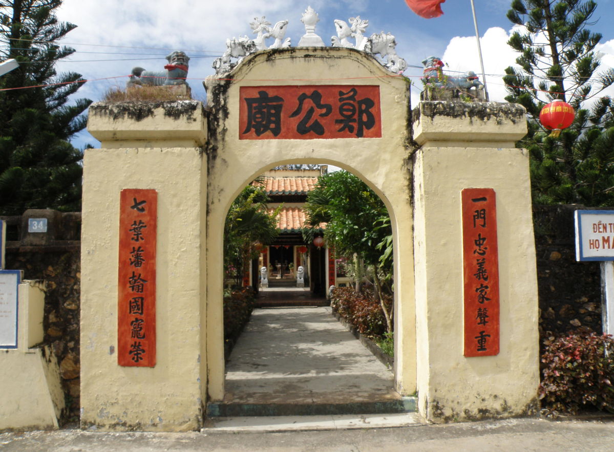
The entrance to the elegant temple for the Mạc family, the 18th century rulers of Hà Tiên. Photo by Mike High.
Early Names: Peam, Cancao, and Ponteamas,
According to Sellers, the provincial capital that bore the name Banteay Meas lay further inland, and the actual port was called Peam> by the Cambodians and Mang Khảm by the Vietnamese.
However, nothing like these names appear on the early western maps of this period. Instead, they show “Langor,” “Corol,” and “Tarvana.” Dutch and English geographies identify these as important towns, but no one has been able to link these names to Khmer or Vietnamese placenames, or even to specific locations. Some cartographers have speculated that “Langor” is actually “Angkor,” but this is not entirely convincing. It would not be unusual for a port to be known by the name of the kingdom, but Angkor was no longer an active polity and it is unlikely that a coastal port would have been associated with the distant ruins of Siem Riep.
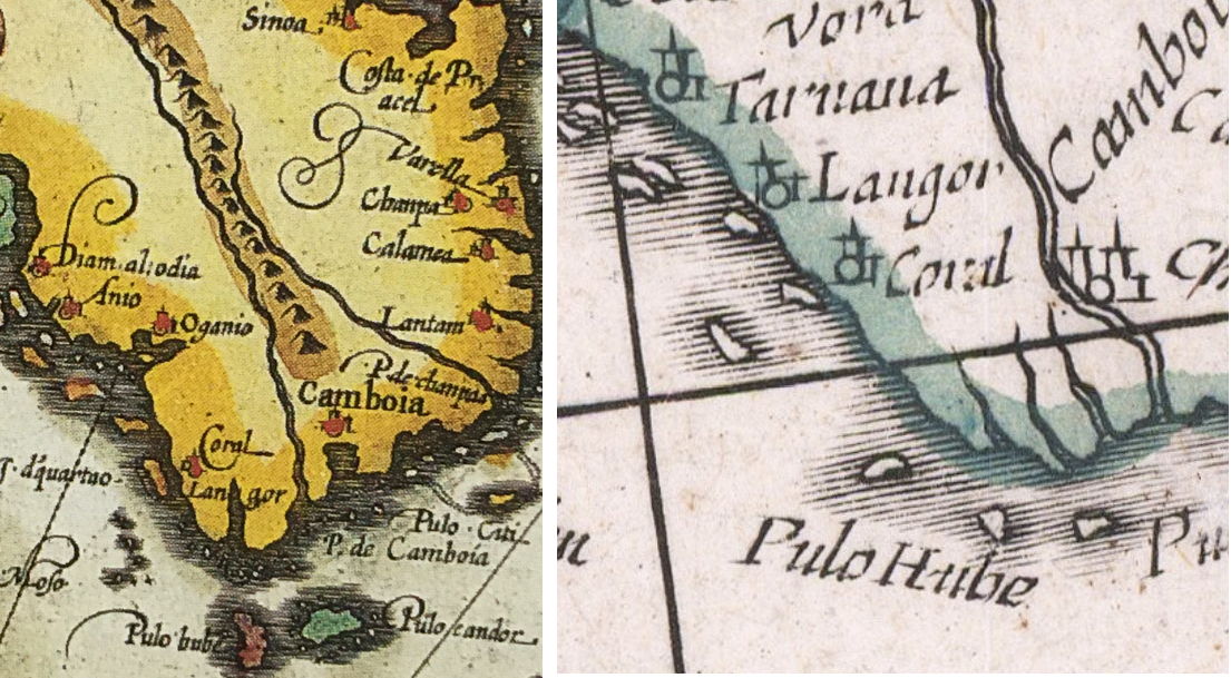
Early maps of the southwestern coast by Hondius (1609) and Blaeu (1635).
In contrast, we have a great deal of evidence that Chinese merchant-captains called the harbor Can Cao, meaning “port mouth,” or, in the English phrasing, “Portsmouth.”
Can Cao
港口
The name “Can Cao” continued to be used during Mạc Thiên Tứ’s reign, and was applied as a political toponym for the entirety of his realm; hence, “Cancao” was sometimes used as a placename on the western branch of the Mekong, probably referring specifically to Trấn Giang (modern-day Cần Thơ).
As western cartographers became better informed about the region, they began to mark the port as Ponteamas or Ponthiamus, a transliteration of “Banteay Meas.” This name began showing up on maps in the middle of the 18th century (ca. 1740s). In Voyages d'un philosophe (1769), Pierre Poivre had it both ways, explaining that he had visited “a small territory called Cancar, and known on the marine charts by the name Ponthiamus” (… un petit territoire nommé Cancar, et connu sur les cartes marines sous Ie nom de Ponthiamas).
NOTE: Nicholas Sellers also identifies Hà Tiên with the port of “Akadra” in Ptolemy’s Geographia (ca. 150 CE), but I have not found corroboration of this assertion in archeological or cartographic studies.
Hà Tiên: River of Spirits
After Mạc Cửu allied himself with the Nguyễn lords, his fief was given the name Hà Tiên, meaning “River of the Spirit(s).” The word tiên (Chinese xian 仙) is a classical term for the Taoist immortals, or “perfected beings,” who are eight in number (in the north, the Vietnamese had their own pantheon of four “immortals”).
Hà Tiên
河仙
The name “Hà Tiên” first appears in the Nguyễn chronicles in 1708, though that is not conclusive evidence of its use at that time. (The official historians could have retroactively applied the term when describing the first contacts between Mạc Cửu and the court at Huế.) The entry for that year notes that the name was given because such immortals had often been seen along the river. It’s possible that this reputation has something to do with the legend that a golden Buddha appeared at the bottom of a nearby stream as an augury of Mạc Thiên Tư’s birth.
The name Hà Tiên, as given by the Nguyễn court in Phú Xuân (Huế), may have been reserved for official communications. In common parlance, as we’ve seen, voyagers knew it either by the Chinese name Cancao or the Khmer name Ponteamus. “Atien” or “Hà Tiên” did not appear on western maps until the early 19th century.
The name Hà Tiên, as given by the Nguyễn court in Phú Xuân (Huế), may have been reserved for official communications. In common parlance, as we’ve seen, voyagers knew it either by the Chinese name Cancao or the Khmer name Ponteamus. “Atien” or “Hà Tiên” did not appear on western maps until the early 19th century.
This was formerly the land of Mang Khảm, Chân Lạp [Cambodia]. It was commonly referred to as the Trúc Phiên Thanh [Bamboo Pennant Citadel] or the Đồng Trụ Thành [Bronze Pillar Commandery). Mang Khảm was also called in Chinese, Phương Thành [Mandarin, Xiangcheng, or Fragrant Citadel].
In the beginning, Mạc Cửu from the Thanh [Qing] [province of] Quảng Đông [Guangdong] came south and took up residence in Cao Man [Cambodia). Seeing that merchants from the various countries gathered in Mang Khảm, he summoned together refugees from Phú Quốc, Hương Úc, Rạch Giá and Cà Mau and set up seven villages under his conlrol. As tradition had it that in the area they were inhabiting, immortals would would often appear from and disappear into the river, they called this area Hà Tiên Quốc [Kingdom of the River of Immortals].
Mạc Thiên Tứ’s “Ten Odes of Hà Tiên”
Mạc Cửu’s son, Mạc Thiên Tứ, was well-versed in classical Chinese tradition, and soon after he succeeded his father, he began to work on a set of ten odes describing the harmonious scenery of his domain—the Hà Tiên thập cảnh (河仙十景).
Mạc Thiên Tứ was well-versed in classical Chinese tradition, and soon after he succeeded his father, he began to work on a set of ten odes describing the harmonious scenery of his domain—the Hà Tiên thập cảnh ( 河仙十景).
The following list combines the names as given by Trịnh hoài Đức (Gia Định Thành thông chí, in quốc ngữ translation (both word-for-word and semantic), with Claudine Ang’s English translation of each title (Poetic Transformations) and the location of each scene (based on Nicholas Sellers and my own best guesses).
1. Golden Islet Blocking Waves
Kim Dữ lan đào (金嶼攔濤)
Dịch nghĩa: Đảo Vàng ngăn sóng
Đại-Kim-Du peninsula, also known as Pháo-dài point: the arm of land that partially encloses the entrance of Hà-Tiên harbor.
2. Verdant Folds of Screen Mountain
Bình San điệp thúy (屏山疊翠)
Dịch nghĩa: Núi bình phong lớp lớp xanh
The east slope of Mỹ-đức Hill (now the site of the Mạc ancestral temple).
3. Dawn Bell at the Temple of Seclusion
Tiêu tự thần chung (蕭寺晨鐘)
Dịch nghĩa: Chuông mai chùa vắng
The Tam Bao Buddhist temple, constructed adjacent to the walls of the Mạc citadel.
4. Night Drum on River Wall
Giang thành dạ cổ (江城夜鼓)
Dịch nghĩa: Trống canh đêm thành lũy bên sông
This scene could have been anywhere along the ramparts that extended along the river, but presumably it was close to the citadel.
5. Stone Grotto Swallows Clouds
Thạch Động thôn vân (石洞吞雲)
Dịch nghĩa: Động đá nuốt mây
Thạch Động mountain, which became the site of a Buddhist cave-temple.
6. An Egret Descends from Pearl Cliff
Châu Nham lạc lộ (珠岩落鷺)
Dịch nghĩa: Cò đậu Châu Nham.
Pearl Cliff is now called Núi Trat; it is part of the Bấi-ớt mountains, forming the tip of a peninsula about 10 kilometers south of Hà Tiên.
7. Moon’s Reflection on East Lake
Đông Hồ ấn nguyệt (東湖印月)
Dịch nghĩa: Trăng in Đông Hồ.
“East Lake” is on the outskirts of the town, surrounded by hills, one of which has a colonial-era water tower.
8. Clear Waves on South Bay
Nam Phố trừng ba (南浦澄波)
Dịch nghĩa: Sóng lặng bến Nam.
Nam Phố is the partially-enclosed bay of Hà Tiên.
9. Rustic Dwellings at Deer Cape
Lộc trĩ thôn cư (鹿峙村居)
Dịch nghĩa: Xóm quê Mũi Nai.
Sellers identifies Lộc trĩ as “Deer Mountain,”
located at the cape; site of old lighthouse.
10. Mooring to Fish at Sea-Perch Creek
Lư khê ngư bạc (鱸溪漁泊)
Dịch nghĩa: Thuyền câu đậu rạch Vược.
Lư khê (Rạch Vươc) was near Thuận Yên village; Mạc Thiên Tứ had a fishing pavilion on its banks.
In my several visits to Hà Tiên, I have tried to visit all of these sites, but have not located the River Wall (Giang thành), though one would think that some traces of the ramparts must remain. Nor have I definitively identified Pearl Cliff. I think I may have stumbled across Sea Perch Creek, but had to depart in haste at the instruction of a soldier carrying an automatic weapon. (The site is apparently on the grounds of an army base.)
It was perhaps formal modesty that prevented Mạc Thiên Tứ from writing a poem to Lũng Kỳ (Trũng Kè), the place where a shining image of the Buddha appeared over the water to herald his birth. Apparently Mạc Cửu had taken refuge in Lũng Kỳ after a Siamese attack—it is said to be in the vicinity of Sihanoukville (Kampong Som), once a part of the Mạc domain but now on the other side of the border with Cambodia.
Another place that has eluded me so far is the exact spot of the Catholic seminary that was set up in Hòn Đất in 1765. The seminary was quickly destroyed and its students scattered in a bloody attack by Siamese raiders, but the young priest Pigneaux de Behaine, who had succeeded to the title Bishop d’Adran, sought to resume missionary work in the region in the 1770s.
Missionary accounts indicate that the short-lived seminary consisted of bamboo and thatch buildings with a view of the sea, so one would not expect to find any archeological evidence of the site. But it seems probable that local memory would have survived, and would especially have been sustained in the French colonial era. The problem is that Bishop Pigneaux and his brethren came to be seen as the vanguard of the French conquest (1859-1884).
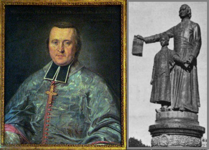
Portrait of Bishop Pigneaux, painted in Paris during his visit with Prince Cảnh in 1785. Left: Postcard image of the statue of the Bishop with Prince Cảnh outside the great cathedral of Saigon (torn down during the “August Revolution” of 1945).
This is a shame, because Pigneaux and Hòn Đất figure large in the grand saga of the Nguyễn restoration, dating from the moment that the itinerant bishop gave shelter to 15-year-old Prince Nguyễn Ánh after most of the royal family had been massacred in 1777. The French would later exaggerate Pigneaux’s contributions to the Nguyễn cause, but the rapport between the future emperor and his special counselor was extraordinary.
When his fortunes were at low ebb in 1785, Nguyễn Ánh entrusted Pigneaux with care of his young son, Prince Cảnh, and sent them on a journey to France to seek support at the court of Louis XVI. The precocious prince, then seven years old, played at court with the French prince, delighted the court ladies, and fielded questions from the American ambassador, Thomas Jefferson, about Cochinchinese rice.
A treaty was signed, promising French military support in exchange for trading concessions, but one of Louis XVI’s ministers almost immediately convinced the king to renege on the bargain. Nevertheless, the French colonialists would misrepresent this 1787 agreement (and Pigneau’s role as Prince Cảnh’s tutor) as symbolic of an early relationship between the two countries—with France already cast in the role of guide and benefactor. And so, it is not hard to see why the statue of Bishop Pigneau was pulled off its pedestal in Saigon so abruptly in August 1945, and why there is little interest in setting up a marker at the site of the Hòn Đất seminary.
Early maps of the southwestern coast by Hondius (1609) and Blaeu (1635).
- The Princes of Hà-tiên (1682-1867). Nicholas Sellers, published by Thanh-Long, Brussels, 1983.
- In 2000, Liam Kelley offered his own take in “Thoughts on a Chinese Diaspora: The Case of the Mạcs of Hà Tiên,”, in Crossroads: An Interdisciplinary Journal of Southeast Asian Studies, Vol. 14, No. 1 (2000).
- In 2007, Li Tana and Paul A. Van Dyke published a fascinating paper detailing the economics of the Mạc city-state (“Canton, Cancao, and Cochinchina: New Data and New Light on Eighteenth-Century Canton and the Nanyang,” Chinese Southern Diaspora Studies, vol. 1, 2007).
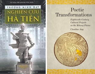
- 2008. A scholarly resident of Hà Tiên, Trương Minh Đạt, publishedNghiên cứu Hà Tiên (Văn hóa - Xã hội, 2008), exploring local traditions and the history of several historical sites.
- 2011. Brian Zottoli provides an extensive comparison of Portuguese, Chinese, and Vietnamese sources (including the Mạc family history, the Mạc thị gia phả) in a thesis titled Reconceptualizing Southern Vietnamese History form the 15th to 18th Centuries: Competition along the Coasts form Guangdong to Cambodia.
- 2019. Claudine Ang adds yet another layer with her fascinating exploration of Mạc Thiên Tứ’s poetical and political collaborations with the Nguyễn-appointed governor of the south (Poetic Transformations: Eighteenth-Century Cultural Projects on the Mekong Plains).
French Sources
- Voyages d'un philosophe ou observations sur les moeurs et les arts des peuples de l'Afrique, de l'Asie et de l'Amérique, P. Poivre, Paris, 1795 (originally published 1769).
- Correspondence by and about Pigneau is collected in Histoire de la mission de Cochinchine 1658-1823 : Documents historiques III, 1771-1823, Adrien Launay, Missions étrangères de Paris, published by Les Indes savantes, 2000.
- Pierre Pigneaux : Evêque d'Adran et mandarin de Cochinchine, Frédéric Mantienne, Les Indes Savantes, 2012.