|
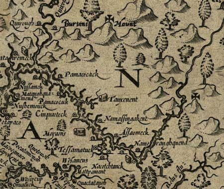
John Smith's map of his travels along the Virginia
coast and the Chesapeake Bay,
shows the furthest extent of his exploration up the Potomac.
According to the map legend, the cross denotes what he knew"by
discoverie,"
the rest of the map was based on what he learned "by relation."
The lower bend
of the Potomac in this detail is where the Potomac meets the Anacostia.
(Map
of Virginia 1624-Sixth State, Library of Congress American
Memory)
|
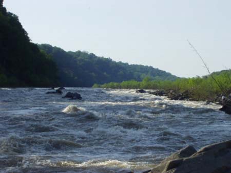
About
5 miles from the juncture with the Anacostia, Smith and his men
would have come to Little Falls, where the Potomac narrows
into a rapid torrent over an obstacle course of boulders.
At that point, Smith's vessel of "two to three tons burthen"
could have proceeded no further, though they might have
explored further on foot and by canoe. (Photo by M High)
|
|
Added
to Mile 4.5 in the Updated Edition:
From
the towpath you can follow a concrete-surfaced road down to the boulder-strewn
floodplain. At the end of the path, you?ll come to a concrete platform
with a good view of Little Falls. This is a good place to take a close
look at the impediment that likely ended John Smith's exploration up
the Potomac in 1608. The Army Corps of Engineers built the platform
in the 1970's as part of an auxiliary system to pump water up to the
Dalecarlia Reservoir in the event of a drought.
|
The
first description of Smith's trip up the Potomac appeared
in The Proceedings of the English Colonie in Virginia, 1612.
Though the book was Smith's, it attributed this account to
two
members of his party of fifteen, Walter Russell and Anas Todkill.
|
THE
PROCEEDINGS OF
THE ENGLISH COLONIE IN
Virginia since their first beginning from
England in the yeare of our Lord 1606,
till this present 1612, with all their
accidents that befell them in their
Journies and Discoveries.
From Chapter 5, "The accidents that happened
in the Discoverie of the bay"
|
|
****
3 or 4 daies wee expected wind and weather,
whose adverse extreamities added such discouragments to our discontents
as 3 or 4 fel extreame sicke, whose pittiful complaints caused us
to returne, leaving the bay some 10 miles broad at 9 or 10 fadome
water.
The 16 of June we fel with the river of Patawomecke:
feare being gon, and our men recovered, wee were all contented to
take some paines to knowe the name of this 9 mile broad river, we
could see no inhabitants for 30 myles saile; then we were conducted
by 2 Salvages up a little bayed creek toward Onawmament where all
the woods were laid with Ambuscadoes to the number of 3 to 400 Salvages,
but so strangely painted, grimed, and disguised, showting, yelling,
and crying, as we rather supposed them so many divels. They made many
bravadoes, but to appease their furie, our Captaine prepared with
a seeming willingness (as they) to encounter them, the grazing of
the bullets upon the river, with the ecco of the woods so amazed them,
as down went their bowes and arrowes; (and exchanging hostage) James
Watkins was sent 6 myles up the woods to their kings habitation; wee
were kindly used by these Salvages, of whome wee understood, they
were commanded to betray us, by Powhatans direction, and hee so directed
from the discontents of James towne. The like incounters we found
at Patawomeck, Cecocawone and divers other places, but at Moyaones,
Nacothtant and Taux, the people did their best to content us. The
cause of this discovery, was to search a gilstering mettal, the Salvages
told us they had from Patawomeck, (the which Newport assured that
he had tryed to hold halfe silver) also to search what furres, metals,
rivers, Rockes, nations, woods, fishings, fruits, victuals and other
commodities the land afforded, and whether the bay were endlesse,
or how farre it extended. The mine we found 9 or 10 myles up in the
country from the river but it proved of no value: Some Otters, Beavers,
Martins, Luswarts, and sables we found, and in diverse places that
abundance of fish lying so thicke with their heads above the water,
as for want of nets (our barge driving amongst them) we attempted
to catch them with a frying pan, but we found it a bad instrument
to catch fish with. Neither better fish more plenty or variety had
any of us ever seene, in any place swimming in the water, then in
the bay of Chesapeak, but they are not to be caught with frying-pans.
|
|
The
General History (1624)
In 1624, Smith published another account of his adventures as The
Generall Historie of Virginia, New England, and the Summer Isles.
Chapter Five "The Accidents that hapned in the Discovery of the Bay
of Chisapeack," used much of the material from the earlier work.
However, the following passage was added, giving more detail on the
point where Smith turned his boat around.
|
|
Having gone so high as we could with the bote, we met
divers Salvages in Canowes, well loaden with the flesh of Beares,
Deere, and other beasts, whereof we had part, here we found mighty
Rocks, growing in some places above the grownd as high as the shrubby
trees, and divers other solid quarries of divers tinctures; and divers
places where the waters had falne from the high mountaines they had
left a tinctured spangled skurfe, that made many bare places seeme
as guilded. Digging the growne above in the highest clifts of rocks,
we saw it was claie sand so mingled with the yeallow spangles as if
it had beene halfe pin-dust.
|
| Text:
This
transcription is found in The
Travels and Works of John Smith (Volume 1), edited by Edward Arbor
and A.G. Bradley.
A
more modern (and superbly annotated) presentation of Smith's works is
found in the three volume Complete Works of Captain John Smith,edited
by Philip Barbour, published in 1986 by the University of North Carolina
Press and the Institute for American History and Culture (Williamsburg,
Virginia). |
