Notes on Conococheague Aqueduct & Cushwa Basin
Reference in C&O Canal Companion: Mile 99.6
|
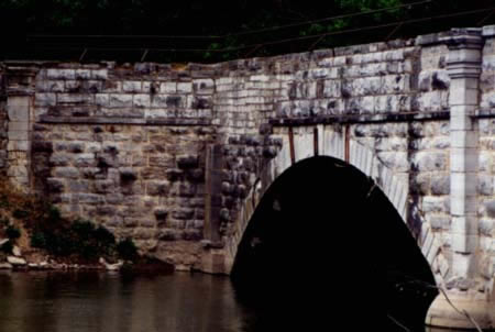
The downstream side of the Conococheague Aqueduct. |
Added
to Mile 99.6 in the Updated Edition:
|
To be added"Conococheague Aqueduct," mile 99.6: This aqueduct has the distinction of being the first one on the C&O that was built in a sizable town (the only other is the Tonoloway Aqueduct, near Hancock). Accordingly, the canal company went to the trouble and expense of adding a few embellishments to the design, including "engaged pilasters" with ornate capitals and bull-nosed piers. The stone was brought down from the "High Rock Quarry" (see mile 102.2). The aqueduct was completed in September 1834, but could not be used until April 1835, when the canal was completed up to Dam #5, which provided the water for this stretch. A Union raiding party under Major Charles Russell, a Williamsport native, tried to destroy the aqueduct during the battle of Antietam (September 17, 1861), to prevent its use by the Confederates in the event that they retreated in this dierction. However, as was the case with the Confederate attempt to sabotage the Monocacy Aqueduct earlier that month, the solid construction of the canal works emerged intact. Unfortunately, when the Confederates were halted at Williamsport during their return from Gettysburg in July 1863, they had a great deal more time on their hands. The canal superintendent for Williamsport reported afterwards that the Confederates had torn the four corners of the aqueduct "down to the bottom," thrown all the coping stone and railing into the creek, and made a breach in one of the arches that nearly bisected the aqueduct. Nonetheless, the aqueduct and the canal were back in operation by August 8. Next year, Confederate raiders managed to tear down some of the stonework on the upper end of the downstream side on August 5th (you can see the irregular alignment of the replacement stones), but the aqueduct was back in service later that month. After the depredations of war and the pounding of floodwaters, the aqueduct's berm wall collapsed in 1865, and was rebuilt in wood. As the canal company started taking in more money, it made more substantial masonry repairs in the winter of 1870-71. A relatively small breach in the berm wall in 1887 was speedily repaired. The last collapse of the berm wall was the most famous --Frank Myers' Boat No. 73 was crossing the aqueduct, headed back upstream to Cumberland after depositing its load of coal in Williamsport, when it nudged the berm wall of the aqueduct. The wall wavered and then collapsed. The cascade of water out of the trunk of the aqueduct washed the boat out into the creek, where it stayed until the flood of 1836 carried it off. Rather than go to the expense of rebuilding the masonry wall, the canal company opted to use wood for the reconstruction, as it had in 1865, but this time with poured concrete between the horizontal timbers and at other strategic spots. *** While the high waters had subsided to the point where it was possible to ferry across at Williamsport by July 13, ferrying was not sufficient to move the whole of Lee's army. Therefore, the infantry, cavalry, and even hapless mules pulling wagons were sent into the fast-moving current. The water was armpit and neck deep, which meant a lot of cartridges got wet in the crossing, and the shorter men had to be supported by their comrades at points where the river bottom dropped away. Most of them made it, but some didn't -- the bodies of mules, horses, and men were found far downstream during the following week. Revision to note for mile 102.2: ... and supplied its "compact blue lime stone" to some of the canal works, including the Conococheague Aqueduct.
Additional NotesAqueduct and Cushwa Warehouse: Park historical studies suggest that the Cushwa Warehouse building, now a canal visitor's center, may have been built around 1800, on land previously occupied by a tobacco warehouse mentioned in the 1786 act of incorporation. Structural studies indicate that the brick warehouse dates back to around 1800. Otho Williams purchased land along the Conococheague in 1786-87, which included the site of the warehouse and Springfield Farms. The Williams family owned the warehouse for many years, eventually leasing it to Charles M. Embrey, who ran a business in coal, cement, iron, and plaster. In 1872, Victor Cushwa entered into an informal partnership with Charles and Thomas Embrey. Victor Cushwa assumed full ownership in July of 1880, and his company continued to use the warehouse as an office long after the canal era ended. In 1974, the warehouse was acquired by the National Park Service. In his Towpath Guide to the C&O Canal, Thomas Hahn attributes the damage on the downstream end of the aqueduct to Mosby's Raiders, but I can find no account that places Mosby this far up the Potomac. Another famous Confederat cavalryman, J.E.B. Stuart did make it up to Williamsport on a diversionary raid after the battle of Antietam, but he did not damage the aqueduct. The Conococheague Aqueduct was designed by the canal company's engineer, Thomas F. Purcell. Among the possibilities considered by the company was a suspension aqueduct. As an economy measure, the canal company had decided on the use "hammer-dressed" rather than cut stone for the aqueducts above the Monocacy. Purcell amended this to allow for smooth cut stone on the inside of the aqueduct, so as to avoid damage to canal boats. The contract for construction of Dam #5, Aqueduct #5, and "all the Locks and Culverts" in that stretch was awarded in late summer, 1833, to a consortium of William and Michael Byrne and Paul Provest, who apparently subcontracted much of the work to Edward Fielding. Michael Byrne & Company was one of the most reliable contractors on the canal, having worked on the Monocacy Aqueduct previously. (Byrne and Company would also end up finishing the canal, working on the Paw Paw Tunnel and on the last and most difficult locks in the mountain regions in 1850.)
|
|
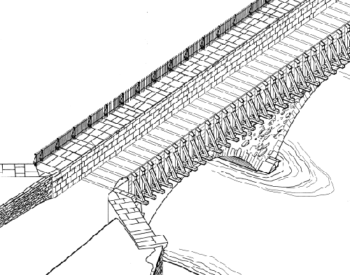
This
rendering shows how the canal company repaired the upstream |
|
Sources:
|