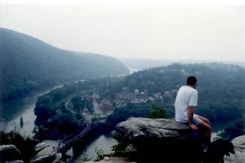
Worth
the hike: the cliffs of Maryland Heights give an exceptional
panorama of Harpers Ferry and the confluence of the Potomac
and Shenandoah Rivers, as well as a good idea of the
strategic advantage of the position. Loudoun Heights loom to the left.
(Photo by M High)
|
The
river lock had a peculiar feature, which led to a great embarassment
for Union General McClellan in February of 1862. As he sent General
Banks' division across the light pontoon bridge that his engineers
had finished just upstrem, McClellan was planning to set up a more
permanent bridge for reinforcements and heavy equipment, using canal
boats as pontoons. But when the canal boats arrived, the engineers
discovered that the river lock was narrower than the standard locks
on the C&O Canal, apparently because it was only intended to
transfer boats from the Shenandoah, which were built to smaller
dimensions. And as it turned out, the C&O boats were 6 inches
too wide to make it through the river lock. While McClellan still
had the pontoon bridge at his disposal, he was sufficiently disquieted
to call off his plans to proceed south to Winchester.
Lincoln
was furious at the delay, perhaps because he suspected that McClellan
was using it as an excuse for halting his forces, but he fixed his
anger on the failure to check the dimensions of the canal lock.
Since McClellan was not nearby, the President instead upbraided
his father-in-law: "Why in the Nation, General Marcy, couldn't
the General have known whether a boat would go through that lock
before spending a million dollars getting them there?" Wags
in Washington summed up the situation by saying that the expedition
had died of "lockjaw."
|
|
Mile
60.7:
Early
in the Civil War, both Union and Confederate commanders recognized
the importance of controlling the "Maryland Heights," that
portion of Elk Ridge that looms over the canal and the town of Harpers
Ferry. Abner Doubleday set about placing artillery here in the summer
of 1861, and a military road was constructed up the face of the mountain.
General Banks believed that "two or three pieces of heavy artillery
will command the town and sweep roads measurably all the roads leading
to it, as the turnpike to Charlestown, the road leading to Leesburg,
and the mountain road from Keys' Ferry to Loudoun Heights, and to
Harper's Ferry across the Shenandoah."
When
Colonel Dixon S. Miles rushed to the town of Harper's Ferry in September
1862 to command its defense, he was well aware of the importance of
the Heights, and ordered that it be defended at all costs. However,
shortly after the Confederates began their assault, Dixon ordered
a withdrawal, with the predictable consequence that the garrison in
Harpers Ferry was soon shelled into surrender. The quick surrender
made it possible for Stonewall Jackson to reinforce Robert E. Lee
just in time to stave off disaster at Antietam.
Colonel
Miles was one of the casualties, which spared him the fate of several
of his fellow officers who were arrested two weeks later and brought
before a military commission that had been assembled in Washington
to investigate this "unfortunate affair." The commission
collected a good deal of material that cast suspicion upon Miles'
judgment and even his loyalty, and concluded that the "strangely
unanimous testimony" demonstrated an "incapacity, amounting
almost to imbecility."
|
Documents
From
the Official
Records, Series 1, Volume 2:
HAGERSTOWN, Mn., June 23, 1861.
Col. E. D. TOWNSEND, Asst. Adjt. Gen. U. S. Army, Washington City:
COLONEL: Up to the present instant I have received from Capt. J.
Newton, Engineer Corps, only a report of a part of his reconnaissance
of the Maryland Heights and the ground adjacent, made in compliance
with the injunctions of the General-in-Chief. I hasten to give the
result thus far, expecting to-morrow evening to present the whole.
Captain Newton approached the heights from this side, ascending
over rough and steep roads difficult for artillery. The summit he
found capable of defense of ample character by about five hundred
men. The main difficulty to be overcome is the supply of water;
the springs, which a week since afforded an ample supply, have become
dry. He found no water within half a mile of the position selected
on the heights for an intrenched camp. In Pleasant Valley, on the
east, near the base of the mountain, springs are reported to abound;
their character will be ascertained to-morrow. Water would have
to be hauled from this valley, and he reports the ascent very difficult.
In this valley I propose to place the force sustaining that on the
heights. The whole command, if the location prove favorable, need
not exceed two thousand five hundred men. That force would render
the position safe; anything less would invite attack. *****
R. PATTERSON, Major-General, Commanding.
|
|
General
Walker's account of the bombardment of Harper's Ferry:
About an hour after my batteries opened fire, those of A.P. Hill
and Lawton followed suit, and near three o'clock those of McLaws.
But the range from Maryland Heights being too great, the fire of McLaws's
guns was ineffective, the shells bursting in mid-air, without reaching
the enemy. From my position on Loudoun Heights my guns had a plunging
fire on the Federal batteries, a thousand feet below, and did great
execution. By five o'clock our combined fire had silenced all the
opposing batteries, except one of two guns east of Bolivar Heights,
which kept up a plucky but feeble fire, until night put a stop to
the combat.
During the night of the 14th-15th, Major (afterwards brigadier-general
of artillery) R. Lindsay Walker, chief of artillery of A.P. Hill's
division, succeeded in crossing the Shenandoah with several batteries,
and placing them in such a position, on the slope of Loudoun Mountain
far below me, as to command the enemies works. McLaws got his batteries
into position nearer the enemy, and at daylight of the 15th the batteries
of our five divisions were pouring their fire on the doomed garrison.
The fire of my batteries, however, was at random, as the enemy's position
was entirely concealed by a dense fog, clinging to the sides of the
mountain, far below. But my artillerists trained their guns by the
previous day's experience and delivered their fire through the fog.
The Federal batteries promptly replied, and for more than an hour
maintained a spirited fire; but after that time it grew more and more
feeble, until about eight o'clock, when it ceased altogether, and
the garrison surrendered. Owing to the fog I was ignorant of what
had taken place, but surmising it, I soon ordered my batteries to
cease firing. Those of Lawton, however, continued someminutes later.
This happened, unfortunately, as Colonel Dixon S. Miles, the Federal
commander, was at this time mortally wounded by a fragment of shell
while waving a white flag in token of surrender.
|
|
Sources:
- George
B. McClellan, The Young Napoleon, Stephen W. Sears, Ticknor &
Fields, New York, 1988, reprinted by Da Capo Press, New York, 1999.
[See discussion of the problem with the river lock on pages 156-158]
- Six
Years of Hell, Harpers Ferry During the Civil War, Chester G.
Hearn, Louisiana State University Press, Baton Rouge, Louisiana, 1996.
- My
Life in the Old Army, The Reminiscences of Abner Doubleday, edited
by Joseph E. Chance, Texas Christian University Press, Ft. Worth,
Texas, 1998.
- War
of the Rebellion, A Compilation of the Official
Records of the Union and Confederate Armies, Series 1, Volume
19. [See Part 1, pages 550-803, for records of the Military Commission
on Harpers Ferry.].
- "Harper's
Ferry and Sharpsburg," by (General) John G. Walker, in The
Century Magazine, vol. 32, issue 2, June 1886, pp. 296-309. [Viewable
on-line as a part of Cornell University's Making
of America collection.]
|
