Notes on Nolands Ferry, Fish Weirs & Rock Dams
References
in C&O Canal Companion:
Mile 43 (to be added), Mile 44.6
|
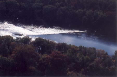
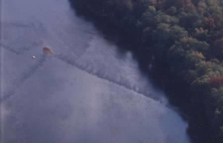
V-shaped
fish trap below Nolands Ferry
|
|
|
Added
to box for "Nolands Ferry" at Mile 44.6, [Nolands Ferry] Originally licensed by Ebenezer Floyd in 1742, ferry operations at this landing were taken over by Philip Noland around 1754. (Noland was the son-in-law of Francis Awbrey, who had licensed a very early Potomac ferry operation at the base of Conoy Island, two miles upstream, in 1735.) Noland competed successfully with Josiah Clapham?s ferry at the mouth of the Monocacy (mile 42.2). To be addedMile 43: A very distinctive boulder in the middle of the Potomac marks the apex of one of the best preserved fish weirs in the lower Potomac region. Canoeists and fishermen on the Potomac can still find traces of numerous rock dams built by Indians and colonists to trap fish. The traps were designed either to channel fish into a narrow sluice enclosed by basket nets, or into a circular pen where they could be easily speared, shot by bow and arrow, or caught by hook and line. (One archeologist notes that small bones, such as the toe of a deer, could be used as a hook for fishing.) Archeologists have identified dozens of these crude structures in the Piedmont and Great Valley, and a 1999 article by Dan Guzy speculates that there may have been many others along the North and South Branches. Between fish traps and mill dams, the Patowmack Company had its hands full clearing a navigable path downriver. Washington's diary of 1785, the year the Company began its work, notes the many manmade obstructions in the Potomac. However, the Company itself also built some rock dams in the river to create sluices and deeper channels that would enable flat-bottom boats to pass during the frequent periods of low water flow. Mile 44.6: An early traveller to take advantage of ferriage here was young Thomas Jefferson on May 10, 1776. Travelling from Charlottesville, Jefferson was using the "upland route" to get to the Continental Congress in Philadelphia, where he would be asked to draft a very important document. By the 1790s, Jefferson was taking advantage of the seaboard route, usually crossing by ferry at Georgetown (see mile 0). *** At its peak, the ferry site included a country store, blacksmith shop, wagon shop, and a tailor and shoemaker. *** The "convention prisoners," as they were known, had laid down their arms in Saratoga in October 1777 and by the terms of the agreement between Horatio Gates and their General Burgoyne, were supposed to be sent back to England. The Continental Congress had refused to ratify this arrangement, and after a year's stay in Cambridge, Massachusetts, approximately 4,300 prisoners headed south on a two-month journey to the "Albemarle barracks" at Charlottesville. The prisoners came down from Wright's Ferry on the Susquehanna, and crossed the Potomac on December 30th and 31st, 1778. During the war, there were precious few occasions when the newly-formed states had to deal with such a sudden influx of prisoners. However, there were enough to require the construction of "barracks" at Winchester in Virginia and Frederick in Maryland, as well as the refurbishing of Fort Frederick (see mile 112.1). In November of 1780 and early 1781, as Cornwallis moved into Virginia from North Carolina, the prisoners in Charlottesville were sent to to the safer realm of Maryland via the Ferry. The wisdom of the move was proven on June 4, when Cornwallis' dragoons chased the Virginia Assembly out of the town and were literally knocking on Jefferson's door at Monticello. By the end of that year, though, Cornwallis' soldiers had themselves become prisoners, and many of them were escorted to this crossing, bound for Maryland barracks. In May of 1781, when General Anthony Wayne was ordered to take his Pennsylvania soldiers to Virginia to help the Marquis de Lafayette fend off Cornwallis, he decided to cross at Noland's Ferry rather than further downstream because of warnings that Cornwallis might be headed to Alexandria. *** Additional NotesNolands Ferry: As a consequence of the 1793 yellow fever epidemic in Philadelphia, the Justices of Loudoun County directed that parties of four men under a "Sergeant or Corporal" be stationed at each of the Potomac ferries to question southbound travellers under oath, and to quarantine anyone from the Philadelphia area for at least six days. Planning for all necessities, the Justices directed several local "gentlemen" to supply provisions to the men on guard -- one Hugh Douglas was appointed this role for Noland's Ferry. Other Loudoun ferries mentioned in this order of October 2, 1793 were Edward's (see mile 30.9), and several that are less well-known: Conn's (probably near the island of that name just above Great Falls), Heater's (mile 48.2), Myer's, Smith's, and Baltz's. *** A "Nolands Ferry" archeological site was discovered in the 1940's by Spencer Geasey on a small bluff overlooking Tuscarora Creek, about 1/4 mile inland from the Potomac. Text excavations in 1978 determined that this was the location of a small village of the Late Woodland period. (Probably settled circa 1500AD by Indians of the "Mason Island Complex," who were moving eastward just as the earlier Woodland tribes who had inhabited the Piedmont Valley were moving below the falls to the tidewater region.)
Documents |
|
|
Maryland
Archives - Archives of Maryland Volume 47 [Th: Jefferson, In Council, Richmond, to Governor Lee] March 12, 1781 The Prisoners of convention & those taken at the Cowpens having been ordered on the late approach of Ld Cornwallis to move on to our Northern boundary, while Congress could be consulted as to what should be done with them, I have received a Letter from the President from which the inclosed is extracted they have I believe reached as far as Winchester from which place they are now ordered to move on to Knowlands ferry, where the President in another Letter informs me your Excellency will have made provision for subsisting & guarding them further on. According to the desire of the Congress expressed in the Presidents Letter I have taken the liberty of communicating this to your Excellency. Maryland
Archives - Archives of Maryland - Volume 45 [Council to Colo Philip Thomas.] November 2, 1781 By a Letter received from Governor Nelson we are informed, Part of the Prisoners captured with Earl Cornwallis is to be stationed in this State, and though the Number to be provided for by us is not mentioned in his Excellency's Letter, we conclude it will not be less than 2000 including Officers, as the whole are to be divided among the States of Virginia, Maryland and Pennsylvania. We apprehend such a Body of Prisoners will require a Guard of three hundred Men, besides Officers; it will therefore be necessary to order out immediately such Companies of Select Militia of Montgomery Frederick and Washington Counties as will be sufficient to compose such a Guard, and until the Select Militia of Washington and Montgomery Counties can be assembled at Frederick Town, the destined Station of the Prisoners, you will order upon Duty such a Number of the Militia at large of Frederick County as, with your select Militia, will amount to the above Number. The Prisoners allotted to this State, will be guarded by the Militia of Virginia, as far as the Verge of that State and will march the most direct Route from Winchester to Frederick Town, and as they are now on their Way it will be incumbent on you to march off your Guard immediately, to such Point as in all Probability, they will be halted at, when the Guard arrives there, the Commanding Officer must take Charge of the Prisoners and march them to Frederick Town.
|
|
|
Horace Hobb's listing of fish traps between Monocacy River and Nolands Ferry:
|
|
|
Some
notable fish traps between Harpers Ferry and Heater's Island,
|
|
|
Notes on fish traps from the articles: The earliest fish dams were likely constructed by Indians, using methods described by a trader named James Adair in his account The History of the American Indians (published in London, 1765). Adair, who had travelled as far as the Mississippi and Florida, described how he had seen Indians catch fish in baskets placed "at a fall of water, where stones are placed in two long sloping lines from each bank, till they meet together in the middle of a rapid stream, where the intangled fish are soon drowned." Fish were often herded into the trap by means of net with "brush-net sinkers" that dragged across the bottom. Hobbs includes photographs of a rock, notched on both sides with a rope groove around the middle, that he found near a fish dam between the lower end of Mason's Island and the Maryland shore (about a mile above White's Ferry). There were other ways of catching impounded fish, but Hobbs notes that fishhooks made of the "toe-bone of a deer" would have been pulverized by now. Another technique, if the fish were large enough, was to spear them or shoot them with bow and arrow, and Hobbs cites a projectile point he found at the sluice of a fish dam between Harrisons Island and the Virginia shore.. Hobbs believes that the distribution of stone fish dams throughout the North American continent indicates that the practice was not adopted by the Indians from the English colonists. The colonists, though, certainly made use of fish dams and may have repaired or modified some of the existing dams in addition to building new ones. Strandberg and Tomlinson, studying the fish traps between Point of Rocks and Harpers Ferry, concluded that fish traps with "straight and regular" wings were of colonial origin.
|
|
Sources on Nolands Ferry:
Sources on the Convention prisoners and other prisoners:
|
|