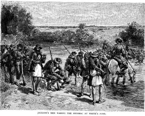
Century
Magazine's depiction of the Army of Northern Virginia crossing
at White's Ford in September 1862.
|
To be added
Mile
38.9:
One of
the more famous accounts of the crossing is that of Jackson's quartermaster,
Major Harmon, employing some of the coarser and more exotic forms of
the Anglo-Saxon tongue to inspire the mules in the wagon train, all
of it within earshot of his devoutly proper commander.
On a few
occasions, Union forces used Whites Ford to cross into Virginia. For
instance, some units crossed what must have been chilly waters in late
October 1862, on their way from the Maryland encampments to the debacle
at Fredericksburg, Virginia. Two years later, several Union regiments
followed Jubal Early's small army across the river in July of 1864,
in lukewarm pursuit.
|
Additional Notes
White's
Ford:
White's
Ford is sometimes confused with White's Ferry (known as Conrad's Ferry
at the time), most notably in Shelby Foote's monumental history of
the Civil War. Other accounts mistakenly place the ford in the vicinity
of the culvert at the Dickerson parking lot. Even the memorial to
the crossing, placed along the towpath a few years ago, is a little
upstream of the ford.
The
precise location, crossing just above the tip of Upper Mason's (Oxley)
Island, is shown on this portion of an 1865 Union map. (The map was
brought to my attention by Charles T. Jacobs, author of the Civil War Guide to Montgomery County, Maryland,
which contains a great deal of information about the Potomac fords
from Great Falls to the Monocacy.) The
location of the island and the ford is also clearly described in several
accounts of the Confederate crossing into Maryland on September 5th,
1862.
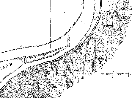
Map
from National Archives Records Group 77 F-93,
surveyed by John W. Donn under the direction of
Major C.S. Stewart of the U.S. Engineers.
|
Documents
from
General Jubal Early's memoir:
On the morning of the 3rd, Jackson's wing commenced the march to
the Potomac, and moved to the left over some country roads, crossing
the Loudoun & Hampshire Railroad at a station, above Vienna, until
we reached the turnpike from Georgetown to Leesburg in Loudoun, and
then along this road through Drainesville, until we passed Leesburg
on the afternoon of the 4th, and bivouacked near Big Springs, two
or three miles from the latter place, at night.
On the 5th we resumed the march and crossed the Potomac at White's
Ford, about seven miles above Leesburg, into Maryland. This ford was
an obscure one on the roads through the farm of Captain Elijah White,
and the banks of the river had to be dug down so that our wagons and
artillery might cross. On the Maryland side of the river the Chesapeake
& Ohio Canal runs along the bank, and the canal had to be bridged
over a lock to enable our wagons to pass, as they could not get through
the culvert where the road ran. That night we bivouacked near Three
Springs in Maryland on the road leading towards Frederick City ....
|
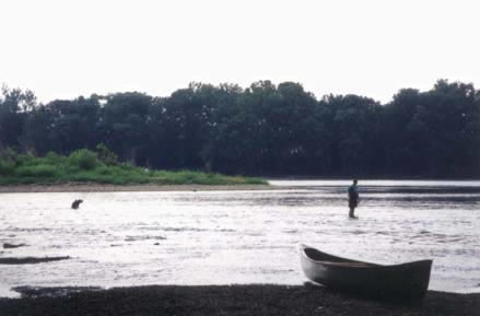
White's
Ford is still easily crossed when the Potomac is at
normal to low flood. (Photo by M High, 1996)
|
|
from Heros von Borcke's memoir:
About two o'clock in the afternoon we received orders to move on,
and after a dusty and very much impeded march of two hours, winding
through infantry columns, and compelled frequently to halt, we reached
the Potomac at White's Ford, where the cavalry were to cross. The
banks of this noble river, which is of great width at this point,
rise to the height of about sixty feet above the bed of the stream,
and are overshadowed by gigantic trees of primeval growth, the trunks
and branches of which are enwrapped with luxuriant vines, that, after
reaching the top, fall in graceful streamers and festoons to the ground,
thus presenting tangles of tender verdure rarely seen in the forests
of Europe. At White's Ford the Potomac is divided into two streams
by a sandy strip of island in the middle. This island is half a mile
in length, an offered us a momentary resting-place half-way in our
passage of the river. It was, indeed, a magnificent sight as the long
column of many thousand horsemen stretched across this beautiful Potomac.
The evening sun slanted upon its clear placid waters, and burnished
them with gold, while the arms of the soldiers glittered and blazed
in its radiance. There were few moments, perhaps, from the beginning
to the close of the war, of excitement more intense, of exhilaration
more delightful, than when we ascended the opposite bank to the familiar
but now strangely thrilling music of "Maryland, my Maryland."
As I gained dry ground, I little thought that in a short time I should
recross the river into Virginia, under circumstances far different
and less inspiring.
The passage of the Potomac by the cavalry column occupied about two
hours, and was attended with some difficulty to our artillery, as
the water in many places rose quite up to the middle of the horses'
bodies. Having safely accomplished it, we continued our march towards
the little town of Poolesville.
|
|
Sources:
- Autobiographical
Sketch and Narrative of the War Between the States, by General
Jubal A. Early, Philadelphia, 1912. [Also available in reprint editions--General
Jubal A. Early was under the command of Stonewall Jackson at the Second
Battle of Manassas and the ensuing Maryland Campaign]
- Make
Me a Map of the Valley--The Civil War Journal of Stonewall Jackson's
Topographer, Jedediah Hotchkiss, edited by Archie P. McDonald,
Southern Methodist
University Press, 1973. [Hotchkiss' account helps place the ford:
"It
was a noble spectacle, the broad river, fringed by the lofty trees
in full foliage; the exuberant wealth of the autumnal wild flowers
down to the very margin of the stream and a bright green island stretched
away to the right."]
- Memoirs
of the Confederate War for Independence, by Heros von Borcke,
W. Blackwood & Sons, Edinburgh, 1866. [Also available in reprint
editions--Heros von Borcke was a Prussian officer of giant stature
who accompanied JEB Stuart's command for much of 1862 and 1863, until
he was wounded on July 19, 1863 in a skirmish at Middleburg Virginia
at the beginning of the Gettysburg campaign. In his writings he often
waxes poetic about the beauties of war, but in this passage his (somewhat
purple) prose pays homage to the Potomac River just below the mouth
of the Monocacy.]
- Civil
War Guide to Montgomery County, Maryland,
Charles T. Jacobs, published by The
Montgomery County Historical Society, 1983 and revised 1996.
- Roads
to Antietam,
John W. Schildt, Burd Street Press.
- One
of Jackson's Foot Cavalry, John H. Worsham, edited by James I.
Robertson, Jr., McCowal-Mercer Press, Inc. Jackson, Tennessee, 1964.
[See page 84]
- The
Comanches: A History of White's Battalion, Virginia Cavalry, written
by Frank M. Myers, Kelly, Piet, & Co., Baltimore, Maryland, 1871.
[Myers was a Captain in White's Battalion, and the front page states
"Approved by all the Officers of the Battalion."].
- The
Rebel Yell & the Yankee Hurrah, The Civil War Journal of a Maine
Volunteer, Private John W. Haley,
edited by Ruth L. Silliker, Down East Books, Camden, Maine, 1985.
[See entry for October 29. 1862]
- 35th
Battalion Virginia Cavalry, John E. Divine, The Virginia Regimental
Histories Series, H.E. Howard, Inc, Lynchburg, Virginia, 1985.
- Stonewall
Jackson, The Man, The Soldier, the Legend, James I. Robertson,
Jr., MacMillan Publishing, New York, NY, 1997.
- "How
Stuart Got Back Across the Potomac," by Col. Wilbur S. Nye, Civil
War Times Illustrated, Volume IV #9, January 1966.
|
