Hancock--the Northernmost Riverbend
Reference
in C&O Canal Companion:
Canal Guide Mile 124.5
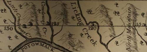
Detail of
Mason & Dixon's map of the Pennsylvania-Maryland boundary line.
(Map as printed in 1909 Report on the Resurvey of the
Maryland-Pennsylvania Boundary)
|
This section
of the map shows how close the line came to intersecting the Potomac
River at the site of present-day Hancock, Maryland. The river lies just
two miles below the boundary line at this point. Note that "Conoloway"
is now known as "Tonoloway" and "North Mountain,"
shown just to the east of Licking Creek, appears under different names
on modern maps.
Since
the Potomac was Maryland's southern boundary, the possibility that his
colony might be truncated by the survey was of some concern to the proprietor.
|
Documents
Lord
Calvert to Governor Sharpe, letter dated January 1, 1754
***
His Lordps desires you will obtain Mr Cresapes Opinion Certain by
Observation of the North Temporary Line. His Majesty's Line by advice
of his Council bet: Maryland & Pensilvania, of wh Line I Learn Mr
Cresap thinks is North of the highest Bend & Flow of Potomack River.
If the Bend is over the Line the Pensilvanians will claim Water Passage
to the Spring Head & on that River; it is of Consequence to know upon
Settlg the North Temporary Line.
***
|
|
Governor
Sharpe was able to reassure Lord Calvert on this point in a letter dated
November 11, 1765.
***
As there are no
Bills yet framed & nothing at present dependig between the Houses
of any Consequence, I propose to leave them for a few Days &
to be at the Meeting of the Commissioners at York Town the 16th
Inst where Messrs Mason & Dixon are to attend us. I have not
for some time received any Letter from these Gentlemen but am informed
by some who have been with them on the Line that having continued
it so far as North Mountain they desisted about a fortnight ago
in order to take an Observation at that place, The Line they have
now described has it seems crossed or intersected the Temporary
Line several Times & the Spot where they broke off is supposed
to be about half a Mile Southward of what was reputed to be the
Temporary Line in that part of the Country for the Temporary Line
was not you know ever continued so far Westward. Capt Shelby who
lives near the North Mountain & went with Messrs Mason &
Dixon to the Top of it in order to view the Course of the Potowmack
says they assured him the Line when continued will not any where
intersect that River & that they apprehended it would run at
least eight or ten Miles to the Northward of Fort Cumberland.
***
|
|
From
the C&O Canal Company's 1832
"memorial" to the Maryland legislature:
This line of
canal will pass through the town of Hancock, in Maryland, at the distance
of six miles from that of Bath, in Virginia [Berkeley Springs], where
it will come in contact with the artificial road between Baltimore
and Wheeling ... The traveller from the west, after crossing the Allegany,
will enter a packet boat at Hancock, propeeled, as those on the Ardrossan
canal of Scotland, at the rate of nine or ten miles an hour, and reach
Washington in a single day of comparative rest.
|
| Map
from reproduction accompanying the Report on the Resurvey of
the Maryland-Pennsylvania Boundary, Part of the Mason and Dixon Line,
Published by the State of Pennsylvania, Harrisburg, PA, 1909
Text
Sources:
- Sharpe/Calvert
correspondence is from Volumes 6 and 14 of the Archives of Maryland,
Correspondence of Governor Horatio Sharpe, William Hand Browne,
Maryland Historical Society, Baltimore, 1895. [On-line at Maryland
State Archives]
- "The
memorial of the Chesapeake and Ohio Canal Company to the General Assembly
of Maryland," reprinted in Memorial of the Corporation of
the City of Washington, Remonstrating Against the Surrender to the
State of Maryland of the stock held by that Corporation in the Chesapeake
and Ohio Canal, March 11, 1840, printed by Blair and Reeves. [The
location of the dam above Cumberland is discussed on page 47.]
|
