Notes on the Potomac Granite Mill and New Foot Bridge Below Widewater
References
in C&O Canal Companion:
Mile 11.75 (note to be added) and Mile 12.3
Photo
from National Park Service files.
|
|
Added
to the Updated edition for Mile 12.3:
This
elegant wood and steel bridge with concrete abutments was one of the
few pleasant consequences of the floods of 1996, replacing the old
earthen dam that supported foot traffic down from the parking lots
off of MacArthur Boulevard (opposite Angler?s Inn).
......
On weekends,
you?ll see a flotilla of kayaks and canoes being carried across the
bridge and down to the river. Experienced paddlers can either play
in the rapids in the riverbend just upstream or take a mild whitewater
excursion down to the the takeout at Lock 10 or below Sycamore Island
(takeout onto the canal at the warning signs for the Little Falls
Dam!).
|
To be added
Mile
11.75:
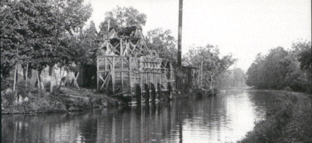
The Park
Service's guide has a picture of the "Potomac Granite Mill,"
but does not place its location. According to Tom Hahn and Bill Davies,
the Granite Mill was located at mile 11.75. (Hahn indicates that the
Mill operation also had a loading dock and rock crusher at mile 12.36).
According to NPS historian Karen Gray, this company apparently operated
in the latter years of the canal, around the late 1800's and early 1900's.
|
|
Sources:
- Towpath
Guide to the C&O Canal, Thomas F. Hahn, initially published
in four parts, published in a combined edition by the American Canal
and Transportation Center, April 1982, and subsequently reprinted
numerous times. [Hahn also conducted at least one survey of canal
landmarks for the National Park Service, a copy of which is kept in
the Park headquarters in Sharpsburg.]
- E:mail
discussion with Karen Gray, referencing work of Bill Davies in addition
to Tom Hahn.
|
