Mason's Island & the Georgetown Ferries
|
Reference:
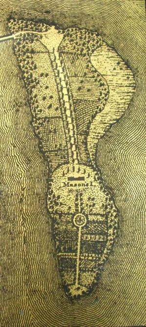
Mile 0 This
detail of Robert King's 1818 map of Washington
|
To be addedMile 0 : The first mention of the island dates back to 1682, when Captain Randolph Brandt took out a patent from Maryland for Analostan Island, or Barbadoes. Captain Brandt was a little ahead of everyone else, as Alexandria and Georgetown would not be settled until the early 1700s. Colonel George Mason III acquired the island in 1724 and bequeathed it to his famous namesake, the author of the landmark Virginia Bill of Rights. A 1737 map of the Potomac shows this as "Col. Mason's Island," and also notes "MaGees Ferry" (sometimes spelled McGee) on the Maryland side of the river, the predecessor to the ferry that Mason licensed in 1748. The ferry crossed between Georgetown and the Virginia shore, usually above the island, though the island had its own ferry landing when the causeway connected it to Virginia. On April 12, 1755, General Braddock commandeered a number of boats in the area to ferry the men of the 48th regiment over to Rock Creek, beginning their journey west via Frederick, Maryland. The boats made their way from the Virginia shore below Mason's Island to a prominence that became known as Braddock's Rock, a natural feature that was quarried down over the years and eventually buried in the landfill that extended the Washington shoreline out into the Potomac. The 48th Regiment camped near the mouth of Rock Creek, where the Ohio Company had set up one of its storehouses, and Braddock's quartermaster built additional sheds here for supplies and munitions. (Also see mile 99.6 for the further travels of the 48th Regiment -- Braddock's other regiment stayed on the Virginia side of the river, taking the road to Winchester.) The Revolutionary War brought another military column through here shortly after September 10, 1781, as Washington and the French general, Rochambeau, sent their "Baggage Waggons, Cavalry, and Cattle" south from Baltimore to cross at Georgetown. The soldiers, on the other hand, embarked on French ships for a brief voyage down the Chesapeake to the siege of Yorktown. By the 1790's, the civilian ferry traffic increased, as Jefferson and Washington made frequent crossings to Georgetown to discuss plans for the Federal City, often en route to the temporary capital in Philadelphia. Of course, the burgeoning business of the new capital would necessitate the construction of bridges, beginning with the bridge at Little Falls in 1797 (see mile 4.2) and the Long Bridge (the forerunner of the 14th Street Bridge) in 1809. Nonetheless, the ferry kept up a lively business until shortly after the Civil War. *** Margaret Leech, the chronicler of Washington's war-time years, noted that when the first two regiments of black volunteers were raised in the District, they were quickly stationed on "Analostan Island" to protect them from harassment. Later that year, when some 960 District residents were drafted (October, 1863), white conscripts were sent to the camp on Analostan Island, while black conscripts were sent to "contraband farms" across the river in Virginia. Analostan was home to soldiers from other states, as well. When the 109th New York State Volunteers arrived in October, 1863, they marched to the island from the B&O railroad depot. Their arrival was noted with great interest by Private Lyons Wakeman of the 153rd New York Regiment, whose real name was Sarah Rosetta Wakeman. Her regiment had been stationed in the area for some time, initially stationed in Alexandria and subsequently performing guard duty at the Carroll Prison on Capitol Hill. She immediately asked for leave to visit her friend Henry Austin and her second cousin, Perry Wilder, who were both serving in the newly-formed regiment from New York. She talked a man in Georgetown into rowing her out to the island, where she was able to spend two hours with Henry and Perry. In 1864, Wakeman and the 153rd Regiment were sent to Louisiana to serve under General Nathaniel Banks in the unsuccessful Red River campaign. As was the case with most Union fatalities in the Civil War, Private Wakeman fell not to a bullet, but to "chronic diarrhea," a pervasive medical complaint. She died in a New Orleans hospital after seven weeks of illness. Web NotesOn the ferry: Another early ferry near Mason's Island had been chartered in 1738 to one Francis Awbrey, who was also connected with ferries far upriver (see mile 44.6, Noland's Ferry). Awbrey's ferry is believed to have crossed the Potomac below Mason's Island, but was short-lived. Awbrey's and Magee's ferries were signs of creeping upriver settlement; the earliest ferry on the Potomac was licensed in 1705 to a gentleman named Fitzhugh, much further down in the Tidewater. In 1720, Hooe's ferry opened a competing operation. Both of these ferries were connected to the post roads leading to Williamsburg in Virginia and Annapolis in Maryland. Not uncoincidentally, these routes lead one to today's Rt. 301 bridge. Fairfax Harrison notes that Fry and Jefferson's map of 1755 shows that an additional postal route had been established, running through Alexandria and crossing to Oxen Creek on the Maryland side. This route likely used West's Ferry, which had been chartered in 1745. Concerning the island: Analostan Island was the site of the first balloon ascent in the District. A young painter from Baltimore, Nicholas J. Ash, was the "aeronaut," and charged 50 cents for those who wanted to observe the event on July 30, 1834. The balloon went aloft at 6 o'clock, and drifted to the northwest and then back over Georgetown, before wafting its way north to a landing about 4 miles above the District. Since the flight could be viewed all over the city, not that many people paid the fee, and that was the last of ballooning in the area until the advent of the Civil War.
|
DocumentsDuring the Civil War, probably in its last year, a pontoon bridge linked the island to Georgetown, as shown in the photo on page 100 of The C&O Canal Companion. These two messages explain the need for the bridge.
QUARTERMASTER-GENERAL'S OFFICE, Lieut. Gen. U. S. GRANT, Commanding U. S. Armies, Washington, D. C.: GENERAL: The Potomac at the Aqueduct Bridge, Georgetown, is narrow, and if the armies, after passing in review, are to return to the south bank of the Potomac, I advise that, to prevent all possibility of accident to the Aqueduct Bridge, a pontoon bridge be laid to Mason's island from the docks of Georgetown, and that they return by this route. It is impossible to know the precise condition of every stick of timber in the Aqueduct Bridge, which is old and has frequently been repaired. Its main timbers are concealed by sheathing. I am,, very respectfully, your obedient servant, M. C. MEIGS, Quartermaster-General and Brevet Major-General. HEADQUARTERS CHIEF ENGINEER OF DEFENSES, Respectfully returned. B. S. ALEXANDER, Lieutenant-Colonel and Aide-de-Camp. From the Official
Records of the War of the Rebellion, |
|
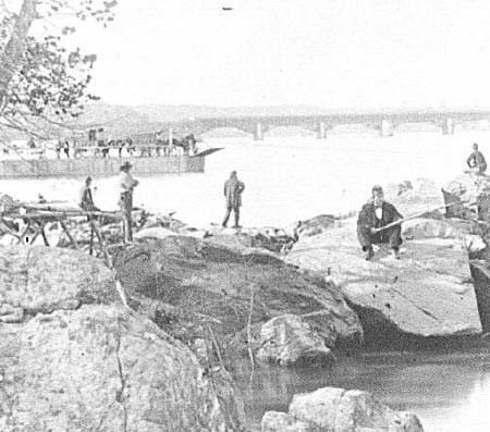
This
Mathew Brady photograph from the upstream tip of the island shows
a ferry
|
|
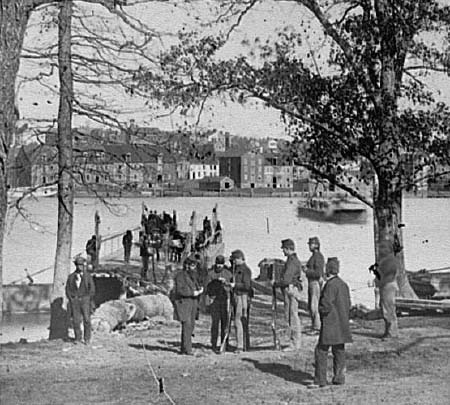
A
Civil War photograph shows another ferry landing on the Georgetown
side |
|
Sources:
|