
Notes on Von Graffenried's Exploration
 |
|
|
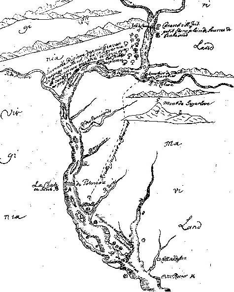
Baron von Graffenried and his associate Franz Ludwig Michel (often referred to as Louis or Lewis Michel) provide the earliest descriptions and maps of the upper reaches of the Potomac. Grafenried's 1712 map is reproduced in many places; Michel's 1707 map is harder to find because of the much more restrictive rules that pertain to British document collections.
|
|
|
When we came to a small village called Canavest, a very pleasant and enchanting spot about 40 miles above the falls of the Potomac, we found a troop of savages there, and in particular a Frenchman from Canada, named Martin Charetier, who had married an Indian woman or savage. He was in great credit among the savages beyond Pennsylvania and Maryland ... This man warned us that the Indians, who were in the vicinity of this mountain of S. where the mines were said to be, were much alarmed by the war which we were having with the Tuscaroras, and told us not to risk ourselves on so dangerous a journey without necessity. We gave heed to this, postponing the plan for a more secure occasion and time. We made an alliance, however, with these Indians of Canavest, a very necessary thing, in connection with the mines which he hoped to finde there as well as on account of the establishment which we had resolved to make in these parts of our small Bernese colony which we were waiting for. After that we visited those beautiful spots of the country, those enchanted islands in the Potomac River above the falls. And from there, on our return, we ascended a high mountain standing alone in the midst of a vast flat stretch of country, called because of its form Sugar Loaf, which means in French pain de surcre ... From this mountain we saw a great extent of the country, a part of Virginia, Maryland, Pennsylvania and Carolina. |
|
|
The day after, we departed in order to return home. We went down the river. For the purpose of the descent the Indians with marvelous skill made us in less than half a day a small boat of the bark of trees. We got into it, five of us, besides two savages, who managed the boat. We even put in our baggage. It was charming going down the river to see the beautiful country on the sides and the pretty islands, but when we came to a great rock in the middle of the river, not far from the falls, as is to be seen on the map, we found the passage dangerous, for about this rock which is almost a little mountain with a pretty plain up on top where an Indian lived, there are still a number of small rocks and great stones, whch make the passages swift, narrow, and bad. I did not want to go down it, and we all got out except Mr. Rosier, who, knowing the skill of the Indians, risked it. When we saw from a distance the turns they had to make, what inexpressible skill it needed to sterr thi canoe or boat, we almost thought there was some magic in the act., and we were very glad to be out of it, especially when we heard the Indians singing as they passed at great speed, almost striking against a great stone or rock. ... At a quarter of a league beyond this bad passage they stopped and we got into the boat again. Good Rosier, still very pale with fear, assured us that he would never be so rash again.
|
|
|
Sources:
|